Hiking (mountain trail, in places narrow and exposed)
Alpine route (equipped or very exposed section, snow field, blocks)
B32
Similaunhütte / Rifugio Similaun » Vent
|
3h35 |
14.9 km
|
23 m
|
1125 m
After a short detour to the Hauslabjoch pass, where Ötzi the Ice Man was found, continue downwards along the Niederjochferner glacier. The Martin Busch hut invites you to take a rest before reaching other interesting relics from past times further away out of the valley, such as the “Hohler Stein” (hollow rock) near Vent.
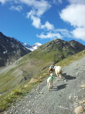
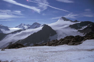
From the Similaun Hut, there is an absolutely unmissable opportunity to make the approx. 40-50min detour to the Tisenjoch pass, to the place at which "Ötzi" the Iceman was found. A monument in several languages indicates the exact spot where he was found. From this point, it is possible to continue directly down over the remaining snowfields and the gravel-strewn cirque in a northeasterly direction. "Beim Bild" brings you back to the marked trail again. It is better and safer, however, to take the marked trail back to the refuge from where an impressive view of the Similaun (3,599m) can be enjoyed. Once at the refuge, keep to the left and follow the path downwards along the Niederjochferner glacier. The trail soon becomes flatter and leads at a leisurely pace over alpine grass to the Martin-Busch-Hut, which lies nestled between Seikogel, Sennkogel and Kreuzkogel to the West and Schalfkogel to the East, all over 3,300m high, and the Schalfkogel even reaches an altitude of over 3,500m (1h30min – 2h). The trail continues in leisurely fashion from the Martin-Busch-Hut. A wide hiking trail now leads steadily downward to the shepherd’s hut, where the trail then swings off to the right to the Ramolhaus mountain hut. Via Alpina, however, continues to follow the trail out of the valley. Slowly, the surroundings become greener and you will reach the meadowland where the little St. Anna chapel is located. According to legend, this was the site of the old Vent. The trail continues along the Niedertalbach stream until a small, inconspicuous path leads off to the left into the pine trees just before Vent. It is signposted with the notice "Hohler Stein". The small detour of approx. 10min is by all means worth it, as the Hohler Stein area really is something quite special! Back again to the wide hiking trail and onwards to Vent, the mountaineering village at the foot of the highest mountain in Tyrol, the Wildspitze standing at 3,774m. (Christina Schwann, OeAV)
Natural and cultural heritage
From the Niederjoch pass via the Martin-Busch-Hut to Vent, Via Alpina follows one of the 17 archaeological theme trails of the Ötztal, Passaiertal and Schnalstal valleys. The A2, as this path is called, comes from Vernagt, crossing the national border at the Niederjoch pass, taking a detour to the Tisenjoch pass standing at 3,210m - where the Ice Man generally known by the name of "Ötzi" was found on 19 September 1991 by a couple called the Simons thanks to the receding glacier - and leading on to Vent. The Ice Man is doubtlessly the most impressive find in more recent history, although flint discoveries also show that the Alps were already being crossed regularly 6-8000 years before Christ. The flint, which originates in the South, was highly treasured by Stone Age Hunters and even reached as far as the alpine foreland as a barter good. It is thought that around 10,000 years ago in the so-called post-Ice Age (post-glacial), most mountain passes were ice-free, thanks to a mild, damp climate airflow (the Atlantic Period). The archaeological theme trails invite hikers to take part in this exciting journey back in time and make many astonishing discoveries. Today, from mid-June until mid-September, the little shepherd’s hut along the trail to Vent is used as a sleeping place by the herdsman from the Schnalstal valley and by shepherds on their way to summer pastures with their animals. Just after this, you will reach the Ochsenleger or Kaser, where the St. Anna chapel was erected several years ago. Legend has it that the old village of Vent stood on this relatively flat land abounding with water. One day, however, a foreign woman who did not dare to cross the Niederjoch on her own asked for shelter, and she was turned away. That night she gave birth to a child and on leaving the then fertile area, she cast a curse on it. Just a little further down in the Niedertal valley, which is now populated with a dense forest of mountain pine, another archaeological find was only recently made. The site is called the "Hohler Stein" (hollow stone). It marks the spot of a Mesolithic hunting ground, used by hunters who tracked their game over alpine passes in the summer months. The site was reconstructed according to its original state and transports visitors back into a long forgotten world. (Further information on the archaeological hiking trails can be consulted in the "Auf den Spuren des Mannes aus dem Eis" and "Ötztaler Alpen – Natur und Kultur" brochures. Both can be ordered online at www.cultura.at/pro.vita.alpina .) Literature: Lesebuch Ötztaler Alpen, Hans Haid, LoewenzahnSölden im Ötztal, Hans Haid, Loewenzahn Auf den Spuren des Mannes aus dem Eis, Archäologische Wanderwege, Hans HaidÖtztaler Alpen, Natur und Kultur, Hans Haid (Christina Schwann, OeAV with the kind support of Dr. Hans Haid)
Other long-distance trails and alternative routes
Detour to the "Hohle Stein" cave just before Vent. Used as a resting place by primeval hunters. central alpine trail (Feldkrich - Hohe Tauern, Hainburg an der Donau) 02
Favourites, criticisms ? Make your personal comments on this stage. For more general notes please use the comments section of the page Over to the Via Alpinists.
Julien - 2020-08-01
Il y a une épicerie qui propose aussi du pain dans le magasin sport 2000.
Po & Ju - 2018-11-06
Malheureusement, les 2 derniers tiers de la randonnée s’effectuent sur une piste bien longue et rébarbative. Nous avons donc décidé de varier les plaisirs en empruntant un sentier qui remonte dans un des vallons perpendiculaires à la vallée principale et qui rejoint Vent par son versant Est. Grand bien nous a pris, les paysages étaient magnifiques, même si l’itinéraire bis ajoute environ 600m de dénivelé positif en plus à l’itinéraire de base, qui en comporte 0. Pour accéder à l’itinéraire bis, traversez le torrent par le pont qui se trouve à environ 2km en contrebas du refuge Martin Busch, par la piste principale. Vent est une petite station en fond de vallée, peu ensoleillée et généralement assez froide. Nous avons bivouaqué à proximité du village, côté Est. Privilégiez le côté Ouest pour bénéficier du soleil au plus tôt le matin !
Automatic translation
[Google]
Unfortunately, the last 2 thirds of the hike take place on a long and forbidding track. So we decided to vary the pleasures by taking a path that goes up in one of the valleys perpendicular to the main valley and joins Vent on its east side. Great good took us, the scenery was beautiful, even if the bis route adds about 600m of elevation gain in addition to the basic route, which has 0. To access the route bis, cross the torrent by the bridge which is about 2km below the Martin Busch hut, by the main track. Wind is a small resort in the valley floor, not very sunny and generally quite cold. We bivouacked near the village, east side. Privilege the West side to enjoy the sun at the earliest in the morning!
Po & Ju - 2018-11-06
Cette belle descente entre les hauts glaciers tyroliens vaut le coup! Ambiance de granit et de glaces éternelles ! Le refuge Similaun est le point de départ de courses d’alpinisme. Le sommet Similaun peut se faire en randonnée glaciaire, avec un équipement d’alpinisme nécessaire et un guide. La technicité de l’approche est peu élevée, ce qui rend cette haute montagne “accessible” pour les randonneurs équipés et aguerris. La descente jusqu’à Vent est majestueuse et très empruntée sur son premier tier. Nous nous enfonçons dans la vallée par un sentier qui serpente au bord du torrent, entouré de hautes montagnes aux couleurs contrastées…
Automatic translation
[Google]
This beautiful descent between the high Tyrolean glaciers is worth it! Atmosphere of granite and eternal ice! The Similaun Hut is the starting point for mountaineering races. The Similaun summit can be hiked with mountaineering equipment and a guide. The technicality of the approach is low, which makes this high mountain "accessible" for hikers equipped and experienced. The descent to Wind is majestic and very borrowed on its first tier. We plunge into the valley by a path that winds along the torrent, surrounded by high mountains with contrasting colors ...
Jean-Louis Giraud - 2014-03-23
Hébergement dans le petit village de Vent:
Haus Elisabeth
Familie Franz Sheiber
Franz Senn Weg 1
6458 Vent, Österreich
+43 5254 8197
ou
A +43 512 9001 17578
www.tiscover.com/elisabeth-vent
Automatic translation
[Google]
Hosting dans le petit village de Vent: Haus Elisabeth VIP Sheiber Franz Franz Senn Weg 1 6458 Vent, Österreich +43 5254 8197 or +43 512 9001 A-17578 www.tiscover.com/elisabeth wind
Monaco - Trieste
MartinBusch Hutte is only 1h30 - 2h max from Vent. wide and smooth path going up.
MartinBusch Hutte - Similaun hutte 1h30
Similaun hutte - Oetzi stele 1h to go...45mins to return without bag
Similaun hutte - Vernago is about an extra 1h30 down
Philippe - 2010-08-05
Compter 1h30 a 2h pour la stele Oetzi en AR depuis Similaun Hutte.Sentier balisé et crodé par endroits.Possibilité de rejoindre Martin Busche hutte directement depuis la stèle sans repasser par Similaun Hutte, mais il faut prendre le sac.Si vous n'avez pas peur de "mettre les mains", allez donc faire un tour à la Fineilspitze, 3514m, , 1h au dessus de la stèle Oetzi, facile et aérien, très beau.
Automatic translation
[Google]
1:30 a 2h count for in Oetzi stele from AR Similaun Hutte.Sentier and marked by crodé endroits.Possibilité joining Martin Busche hut directly from the stele without returning Similaun Hut, but we must take the sac.Si you do not afraid to "get their hands", go have a look at the Fineilspitze, 3514m,, 1h above the stele Oetzi, easy and airy, very beautiful.

 |
3h35 |
14.9 km
|
23 m
|
1125 m
|
3h35 |
14.9 km
|
23 m
|
1125 m


Favourites, criticisms ? Make your personal comments on this stage. For more general notes please use the comments section of the page Over to the Via Alpinists.