Hiking (mountain trail, in places narrow and exposed)
Alpine route (equipped or very exposed section, snow field, blocks)
R1
Muggia (Trieste) » Rifugio Premuda
Trail crossing
|
5h00 |
14.1 km
|
138 m
|
46 m
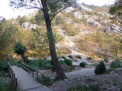
From Marconi Square in Muggia the route climbs to the village of Santa Barbara. Trail 1 goes towards Rabuiese and Vignano woods, later crossing the valley of the Ospo stream. The trail climbs again to Caresana then on to San Dorligo della Valle and the Premuda hut is not much further.
The Via Alpina trail, marked CAI, with red-white-red stripes, begins at the Castle at Muggia. The trails are the same ones as the inhabitants of the Karst used in the past to take what little produce they had to market. The route through the village of San Dorligo della Valle and on to the entrance to the Rosandra valley is along the roman aqueduct that provided water to Tergeste, and then along the ancient “Via del Sale" (salt route). Continue past the salt plains near Muggia to the high plateau of the Karst and inland Istria. The route then takes the walker through the beautiful Rosandra valley, where the most famous mountaineers from the Giulia region (such as Comici and Cozzolino) have displayed their talents, and to the Premuda hut (open all year round), at 68m above sea level. This is the Italian Alpine Club’s lowest hut, near magnificent limestone cliffs, and home to one of the most prestigious Mountaineering Schools (trail 13/1). (Vittorio Aglialoro)
Natural and cultural heritage
From Trieste public transport provides access to the charming little Venetian town of Muggia, which already shows elements of Illyrian influence as well as that of the Karst, from where Slav culture has always filtered in to entwine itself with its Venetian origins and, more recently, four hundred years of Hapsburg influence. The Via Alpina route begins here, from the pleasing piazza del Municipio square and the typical façade of the Duomo. It climbs to the Castle and the Roman site, above which sits the Shrine of the Madonna, protector of sailors. Man has marked the landscape of the area and there is plenty of evidence of this along the way, from the sandstone quarries to the salt works. Past the natural oasis of the Noghere lakes and the Ospo stream, the trail heads up the slopes of the hills of the Karst that sit above the village of San Dorligo della Valle/Dolina and mark the borders of the wonderful Val Rosandra valley. (Vittorio Aglialoro / Alessandro Pennazzato)
Favourites, criticisms ? Make your personal comments on this stage. For more general notes please use the comments section of the page Over to the Via Alpinists.
Carsten Holz - 2023-10-02
Walking the red trail in the summers of 2021-23, I kept (some) track of water availability, bivouac possibilities, grocery stores en route, possibly difficult passages, and thoughts about alternative routing. -- Entered here for R1-R40, but not for R41-R161 due to the space limit on personal comments. For full notes covering all stages see http://carstenholz.com/Via-Alpina.pdf
Angegebene Höhendifferenzen sind völlig falsch. Da im Rifugio Premuda nicht mehr übernachtet werden kann, sind wir nach Pesek zum Hotel Pesek weitergewandert. Von Muggia Porto San Rocco nach Pesek 24.7 km, 1225 Hm Aufstieg und 755 Hm Abstieg. Reine Wanderzeit knapp 7 Std.
Mochileranja - 2023-06-16
Inspired by the poem below (thank you Rembert!!) I took the boat from Trieste to Muggia which was a lovely start for this tour that I really enjoyed! Yes, there are some parts where you have to walk by the road but there wasn’t a lot of traffic (on a Friday), I didn’t feel unsafe and there are other paths that are quite nice and I already ran into a deer and it’s fawn and a whole family of wild boars (what a first day)! Komoot gps worked perfectly fine for me and I recommend following it to get out of Muggia. Afterwards there’s quite good marking except for the one time where you have to walk below the highway - I ended up walking next to the road and the roundabout, but I’m sure there’s a better option that I didn’t see. Finding accommodation at the end of this stage wasn’t too easy (I didn’t have any reservation) but the Refugio Premuda allowed me to set up my tent on their premises for free :-)
Rembert - 2023-04-09
As noted by others
According to my Komoot track it is 670 m up and 540 m down.
Very different from the headline as per this website.
That information is definitely wrong, and should be corrected.
It is a nice stage and well worth I to include.
Rembert - 2023-04-08
Haiku Via Alpina
Let’s go for a walk
Twenty five hundred k-m’s
We wander the alps
Red Route -Alpine bow-
Ten year plan? Start with first step.
Backpack light. Prepare.
1/161 Monday April 3, 2023
Touch water - be blessed
Triest - Muggla by boat
Piazza - We start!
Old olive orchards
Mediterranean views
Fruit trees, barking dogs
Less and less houses
Nature now, path becomes small.
No signs? Continue.
Blue skies, chilly winds.
Spring expected soon - still cold
Lunchtime at church steps
Steep steep scramble down
Triest still near, start is made
Happy end day one
Alpine hut closed
Shop and bed nearby. Tired.
Finished. Good Night.
waso - 2022-08-02
R01 von Muggia nach Rifugio Premuda am 21.06.2022 nur noch essen am Wochenende. Also keine Übernachtungen mehr möglich.
Susan Heule - 2022-06-03
Sehr schlecht bis überhaupt keine Wegmarkierung. Ohne GPS ist der Weg nicht zu finden.
Carsten - 2022-01-23
The city is present almost everywhere along the trail, if not with road walking then in sight and sound. If I had to redo this stage, I would slackpack it: Stay in Trieste, take a very early bus to Muggia (4:57am) to avoid the current 34 degree afternoon temperature, and at the end of R1 walk 10min to the bus stop in the village to head back to Trieste and be in a shower and an air-conditioned room by 11am or 12 noon. Or consider walking out of Trieste and start with R2 (skipping R1 altogether). If I were to redo R1 (with full backpack) and wanted to continue into R2 without a night back in Trieste, I would cut out the poor descent from the final high point at 420m and descend on the *other* side of the hill on what looked like a very decent trail from afar to reach a point roughly 2km into R2, at the bottom of the valley.
Carsten - 2022-01-23
Muggia: From bus terminus (bus 20 from Trieste runs around the clock) head back about 100m to the road into town and follow the signs to (the starting point) "municipio," approximately 200m away, the piazza on the left behind a building. In the South-East corner of the piazza is a postcard-sized sign "Alpe-Adria Trail" attached to a pole. Do not go into that street and up to the castle. Instead, head inland (South) through a pedestrian passage. At the end of it, at a road, there will likely be another sign. Check across the street (heading South) if there are further signs. Eventually, one walks on the road to Santa Barbara (if need be, put into google maps). From Santa Barbara, the trail is well marked, with two exceptions (1) in the approach to the motorway (probably do not turn towards the motorway at the first opportunity); (2) near the final high point of this stage at 420m the trail heads down to the left (North) and does not continue along the ridge to a grotto (end-of-trail).
carstenholz - 2022-01-10
Confusing trail out of Muggia; 2+ trails before Laghetti delle Noghere; nice highline trail in woods in second half. GPS markers misleading (trail can be 1-2 km distant from the line that connects two GPS points), and often wrong. Summary altitude statistics grotesquely wrong -- probably a '1' missing in front (add 1000m), altitude diagram is plausible except that the last hill is 420m high, not 200. Careful at the intersection below Cresana / Mackolje (as identified on the app Maps.me). 20m past the intersection, the trail heads into the bushes on the left, with the paint marks overgrown. There is no water during this stage except a little creek (good flow 30 June 2021, do not cross at first encounter, trail continues to head up another 50m) about 70% into the stage, at 45°35'49.3'N, 13°51'18.3'E, needs filtering, and a fountain (acqua non potable) about 80% into the stage at 45°35'57.2'N, 13°51'34.2'E. "
In the description of this stage at the heading, it says there is 138m of ascent and 46m of descent. This is clearly wrong (maybe right if travelling by road).
Trieste - Monaco, Sommer 2020: Tipp: Ich machte neben Strepeis in Bagni di Vinadio im Hotel Corborant eine Pause. Es gibt einen Pool (der zwar schon geleert wurde) aber noch viel besser: 3-5 Minuten laufen vom Hotel in Richtung Tal und man kommt durch einen kleinen Weg zu den heissen Quellen mit drei Naturpools. Tolle Beinmuskulaturentspannung!
Robert - 2019-12-07
@Claire Try an other Browser, specially if you are on a mac. I was't lucky with Safari, but Firefox worked fine.
Claire - 2019-11-09
We are currently preparing for the red trail of the via alpina but we can't download the guidebook, even for just two stages. If you could help us it would be great, thanks in advance.
kessel_kolumna - 2019-06-25
Wir fanden es auf der ersten Etappe nicht schwer, den Weg zu finden. Wichtig ist, dass man hier wirklich den rot-weißen Markierungen folgt, bzw. dem AlpAdriaTrail, der parallel verläuft.
Da wir rund um die Rifugio Permuda keine Unterkunft gefunden haben, sind wir weiter bis Draga und der Locanda Mario. Das hat für uns wunderbar gepasst.
Automatic translation
[Google]
We did not find it difficult to find our way on the first leg. It is important that you really follow the red-white markings, or the AlpAdriaTrail, which runs parallel. Since we have found no accommodation around the Rifugio Permuda, we are on until Draga and the Locanda Mario. That was perfect for us.
Via Alpina International Secretariat - 2019-06-17
@Gian franco Basso
Dear Gian thank you for your comment. We are currently working on web re-lounch and hope to remove all mistakes and upgrade trail descriptions and GPS data. Please send us email on mail@via-alpina.org about the problems you have had on this stage.
Best regards,
Via Alpina team
Gian franco Basso - 2019-06-17
a destination de l'administrateur pourquoi sur le site Via Alpina l'itinéraire du depart piazza Marconi jusqu'a santa Barbara (agglomération) n'est pas détaillé avec precision
Automatic translation
[Google]
to the administrator why on the Via Alpina site the itinerary from Piazza Marconi to Santa Barbara (agglomeration) is not detailed with precision
Gian franco Basso - 2019-06-17
le balisage a été amelioré par rapport a 2016 mais il reste encore des lacunes notamment a partir de la piazza Marconi et en agglomération sans GPS un peu galère
Automatic translation
[Google]
the markup has been improved compared to 2016 but there are still gaps, especially from piazza Marconi and agglomeration without GPS a little hassle
Gian franco Basso - 2019-06-17
Trieste je recommande l'auberge de jeunesse ostello Tergeste 39040224102 située hors ville a Miramare, face a la mer a coté du chateau 21 euros la nuit avec Petit déjeuner
tres fréquentée ,demander suivant possibiltés un dortoir tranquille. acces:
de la gare prendre le bus n°6 vers miramare
pour le départ vers muggia bus le premier vers 5 h descendre a la gare ,correspondence avec le 20 pour Muggia terminus.
a destination,chercher la piazza Marconi ou aucune indication visible ne formalise le début de la VIA ALPINA,déplorable
Automatic translation
[Google]
Trieste I recommend the hostel ostello Tergeste 39040224102 located off town in Miramare, facing the sea next to the castle 21 euros a night with Breakfast very frequented, ask following possibiltés a quiet dormitory. access: from the station take the bus no. 6 to miramare for the departure to muggia bus the first towards 5 am to get off at the station, correspondence with the 20 for Muggia terminus. to destination, look for piazza Marconi or no visible indication formalizes the beginning of VIA ALPINA, deplorable
Gian franco Basso - 2019-04-23
fait en sens inverse refuge koca na kokosi- Muggia- San Bartolomeo (camping) dernière étape exaspéré par le balisage final j'ai terminé par la route (bord de mer) a partir de Rabuiese
Automatic translation
[Google]
on the other side refuge koca na kokosi- Muggia- San Bartolomeo (camping) last stage exasperated by the final markup I ended by the road (seaside) from Rabuiese
Barbara/Peter - 2018-07-14
Nächtigung im Refugio Premuda nicht möglich. Aber gleich dahinter "Bed and breakfast" - sehr nette Bewirtung und Zimmer mit Dusche
Automatic translation
[Google]
Overnight in Refugio Premuda not possible. But right behind it "Bed and breakfast" - very nice hospitality and rooms with shower
Chantal Tentorini - 2015-09-24
En effet, les traces gpx du premier jour données par John sont excellentes. Aucune erreur de parcours le premier jour!
Automatic translation
[Google]
Indeed, gpx traces of the first day given by John are excellent. No error of course the first day!
Regina - 2015-08-01
Wanderung in umgekehrter Richtung: Der Weg nach Muggia ist in der Tat nicht ganz so einfach zu finden. Bin ab dem Refugio Premunda zuerst dem blau weißen Kreis gefolgt (in den Ort und dort dann links abgebogen) und ab dann dem Alpe Adria Trail nach Muggia. Das war relativ gut ausgeschildert und war gut zu begehen.
Automatic translation
[Google]
Walk in the opposite direction: The Way Muggia is not quite as easy to find, in fact. Bin first followed the blue and white circle from the Refugio Premunda (in the village and there turn left bent) and then from the Alpe Adria Trail to Muggia. It was relatively well signposted and was good to commit.
Brigitte Duquesnay - 2014-07-29
Thank you John (22/07/2014)for the GPS data. We begin to walk at the end of August and we worried about this part of the route...
Brigitte Duquesnay - 2014-07-29
Thank you John (22/07/2014)for the GPS data. We begin to walk at the end of August and we worried about this part of the route...
John - 2014-07-22
There is MUCH better GPS data available for this part of the route on Waymarked Trails. You can download an accurate GPX track here: http://hiking.waymarkedtrails.org/nl/?zoom=17&lat=45.60331&lon=13.76494&hill=0#routes / There is also GPX data available for the other parts of the Via Alpina! Enjoy
Our B&B is just few hundreds metres from Rifugio Premuda. We are open all days of the week for anyone who wants to stay for the night ! Breakfast , wi-fi and private bathroom included in the price ! Booking the room in advance is strongly recommanded since we have got just one room ( max 3 people) . For more info visit our site: www.invalle.com or our facebook page www.Facebook.com\bebinvalle
Paul - 2013-08-06
The trail is really bad marked on the first two days. You can expect hours of looking for signs, checking your map and asking people (who, by the way have never heard of any "via alpina").
Very disappointing all in all. Don´t just follow the blue/white marks, they don´t necessarily lead to a prepared trail. Following those signs we walked for 4h longer than expected on the first day.
Andrea - 2013-05-27
Take the ship from Trieste to Muggia! It takes only 30 min, cost is 4€. Timetable see: http://www.triestetrasporti.it/index.php?trieste-muggia-giornaliera-annuale
John from Bath - 2013-05-21
The directions are poor for the first stage and a half. Bus 20 takes you from Trieste to Muggia (supermarket here). Get a street map of Muggia, look for via Colarich where the paint marks start, then right up via di Santa Barbara, looking for steps up into the village on R. Take village street up to church (tap). Path starts just below church.
Henk - 2013-04-21
The path is now well marked. You will find different trail names, being the same route: Traversata Muggesana, CAI 1, Alpe Adria Trail. If sleeping in Rifugio Premuda is not possible, you can continue the VA for 1 hour till Pese where there is a modern hotel.
Mountain Girl - 2012-12-22
You will be following the "Traversata Muggesana" from Muggia. More people have heard of this path (when you stop to ask for directions, which you invariably will) than have heard of Via Alpina.
Elisabeth - 2012-11-12
Pas de mise à jour en 2012 du topo-guide R1 : le départ n'est pas au château de Muggia et de toute façon il n'y a pas de balisage au départ... et ensuite si peu ! A l'entrée de Dolina, cela manque vraiment. On devrait préciser que le "refuge" Premuda n'est pas un refuge !!
Automatic translation
[Google]
No update in 2012 guidebook R1: The departure is not the castle of Muggia and anyway there is no signage at the start ... and then so little! At the entrance of Dolina, really miss it. We should point out that the "safe haven" Premuda is not a refuge!
Mountain Girl - 2012-06-04
"Rooms" in Bagnoli della Rosandra: "Camere Alpi", Gabriella Zerjal, cell: 33 817 51279, home: 040228438. Rooms are located in Bagnoli central square, about a 5 min. walk before you get to Refuge Premuda. Gabriella is a wonderful hostess. Bagnoli has a supermarket, pizzaria & fresh fish place.
Via Alpina International Secretariat - 2011-12-08
@Daniel: thanks, we have updated the coordinates and hope to be able to upload detailed tracks in the not-too-far future. And yes accommodation is now in Bagnoli della Rosandra.
In the Refuge of Premuda there is no accommodation. But do not despair. The warden will phone the nearby B&B to book a reservation for you. Then have diner at the Refuge and after walk a kilometer down the valley to the square in the nearby village. The lady is very hospitable and friendly, she will even offer to pick you up! 25 euro pp +bf. Very well recommended!
IMPORTANT NOTE: The marked endpoint of the R1 stage is NOT Premuda! The refuge is one kilometer before, at coordinates: 45.6194,13.8659. On the entire Italian part the GPS-track is very inaccurate and misleading. From Trieste to Premuda follow the red-and-white track number 1, and be very careful for sudden turns!
Alpinisten - 2011-09-26
Den Wegbeginn findet man, indem man in Muggia am Rathausplatz vorbei geht (Salita delle Mura) und dann die Via Roma quert in die Via Gabriele d´Annunzio. Dort ist auch das Wanderzeichen der Traversata Muggesana zu finden. Dennoch wäre ein Via Alpina-Schild hier zu Beginn des Roten Weges wünschenswert.
Automatic translation
[Google]
The trailhead can be found by on the main square in Muggia passes (Salita delle Mura) and then crosses the Via Roma in Via Gabriele d'Annunzio. It also describes the character of migrant Traversata Muggesana be found. Nevertheless, a Via Alpina sign would be desirable at the beginning of the Red route.
Janek - 2011-07-21
I don't know about this year, but last year when I started there was no sign indicating the start of the trail. Maybe there is one know, but I would have liked to take a picture of me in the beginning of that adventure I wa about to embark.
WestCoastHikers - 2010-09-06
After leaving Santa Barbara there is basically no place to get anything to drink. Make sure to take plenty of water.
WestCoastHikers - 2010-09-06
In this stage when the trail meets a road it is usually easy to go the wrong way, as there are no markings at those points. Turning left is almost always the right thing to do even when it looks wrong (like on the way up to Caresana).
vohi - 2010-09-01
Wir sind direkt von Matavun nach Trieste gelaufen.. An halbem Tag gut machbar..(teilweise muss wg schlechter Wegweisung jedoch der Weg entlang der verkehrsträchtigen Straßen gewählt werden)
Der Müllanteil in der schönen Landschaft nimmt stetig zu.. Wir sind in Italien angekommen!
Wieder Erwarten war die letzte Etappe für mich die unattraktivste (Müll, schlechte Wegweisung, für mich unschöne Hafenstadt Trieste, dazu kam Regen...).
Trieste: Ein Gewirr an Unterkünften (alle mit Sternen ausgeschildert), aber relativ teuer (3 Sterne min. 60 Euro pro Nacht)
Automatic translation
[Google]
We went directly from Matavun Trieste .. At half day .. quite feasible (some have wg bad signposts along the way but the traffic prone roads are elected)
The proportion of waste in the beautiful countryside is steadily rising .. We have arrived in Italy!
All expectations was the final stage for me the least attractive (garbage, poor signposting, for me ugly port city of Trieste, it started to rain ...).
Trieste: A tangle of accommodation (all marked with stars), but (min 3 stars 60 Euros per night.) Relatively expensive
gonzom - 2010-08-10
Nice housekeepers (and sensual waitress), they show me a good place to put up my tent - for free
ROUSSELLE - 2010-01-06
Pour éviter le refuge Premuda, à partir de San Dorligo monter au Mont Carso (438m) et descendre sur la Chapelle Ste Marie puis Bovac : Vue magnifique sur Tieste. Continuer ensuite sur Draga Sant' Elia : Hôtel Locanda Mario (voir étape R2)
Automatic translation
[Google]
To avoid Premuda refuge, from San Dorligo climb Mount Carso (438m) and down to the Chapel of St. Mary and Bovac: Beautiful view Tieste. Continue on Draga Sant 'Elia Hotel Locanda Mario (see step R2)
Bi - 2009-10-19
Mit Bus 41 bis Mocco. Von Mocco aus via Refugio Premuda nach Divaca. Übernachtungsmöglichkeit in Hotel
Automatic translation
[Google]
Bus with 41 to Mocco. By Mocco from Refugio via Premuda after Divaca. To stay in hotel
miriam - 2009-09-04
Refugio Premuda ist zwar als erstes Etappenziel angeschrieben, aber es bietet keine Übernachtungsmöglichkeit an - dessen sollte man sich bewusst sein, wir haben es leider übersehen und vertrauten auf die Beschreibung.
Automatic translation
[Google]
Refugio Premuda Although written as a first milestone, but it does not provide overnight accommodation - which you should be aware, we have unfortunately overlooked and had confidence in the description.

 |
5h00 |
14.1 km
|
138 m
|
46 m
|
5h00 |
14.1 km
|
138 m
|
46 m


Favourites, criticisms ? Make your personal comments on this stage. For more general notes please use the comments section of the page Over to the Via Alpinists.