Randonnée (sentier de montagne, parfois étroit et exposé)
Randonnée alpine (passage équipé ou très exposé, névé, blocs)
R7
Idrija » Planinska koča na Ermanovcu
|
7h00 |
25 km
|
1278 m
|
664 m
Cette étape fait connaître le massif d’Idrija et parcourir celui de Cerklje. Monter un sentier forestier escarpé. Continuer à travers forêts et prairies abritant de nombreuses fermes, églises et hameaux. Suivre la route goudronnée surplombant la vallée de l’Idrijca tout en restant prudent.
De la gare routière d’Idrija, prendre la route à droite en direction de l’est, traverser la rivière Idrijca et remonter la rue Župančičeva ulica. Prendre un sentier pierreux et pénétrer dans une hêtraie puis suivre un sentier escarpé qui s’élève au-dessus de la vallée. On arrive à un chemin carrossable que l’on suit tout en prenant un sentier pour couper les tournants. Continuer en direction de l’est. Quand on arrive à la fin de la forêt, quitter le chemin carrossable et monter à travers prés vers la route qui conduit au petit village de Gore. 1h 25 min. Tourner à gauche sur la route goudronnée qui monte le versant sud du Cajni vrh. En contournant ce sommet, on descend légèrement jusqu’au hameau de Ledinsko Razpotje, où on rejoint la route régionale qui mène à Spodnja Idrija. Prendre cette route à droite et, 100 m plus loin, tourner à gauche sur la route qui conduit au petit village de Pečnik. Suivre cette route jusqu’au prochain croisement, tourner à droite, traverser l’alpage et rejoindre le village de Ledine. 1h 30 min. Traverser le village, passer l’église en restant sur la route locale et arriver au cimetière des Partisans. Rester sur la même route qui monte ensuite le versant ouest boisé du Trepalova Sivka. On arrive alors à un croisement situé au niveau du col. 30 minutes. Continuer sur la route qui descend, jusqu’au croisement avec la route qui part vers Žiri à droite. Prendre la route locale qui conduit au village de Sovodenj. 5 minutes plus tard, prendre le sentier à gauche qui traverse des prés. 10 minutes plus tard, on retrouve une route forestière près d’une demeure. Suivre pendant 10 minutes cette route relativement plane puis tourner à droite et marcher jusqu’à la demeure des Likar à hauteur de laquelle la route cesse. Continuer sur un chemin carrossable qui devient un sentier qui descend en pente raide à travers prés et rejoint une demeure. Continuer peu de temps sur une route, tourner et s’engager sur un chemin carrossable, un peu plus en hauteur, qui descend jusqu’à un lotissement de résidences secondaires. Tourner à droite sur une route forestière et continuer jusqu’à une route goudronnée à hauteur de la demeure Lanišar. 45 minutes. Tourner à droite sur la route et monter jusqu’au col. Une petite chapelle se trouve au bord de la route. Tourner à droite pour prendre une route en moins bon état et monter jusqu’à une route forestière qui conduit à la ferme Pleč, à hauteur de laquelle on arrive sur un chemin carrossable. Prendre un sentier qui traverse des prés et rejoindre un chemin carrossable qui amène tout en dessous du sommet Bevkov vrh (1051 m). Traverser la route forestière, passer la grande demeure de Bevk, puis les piliers d’un ancien kozolec (grenier à foin) et arriver à une petite chapelle située au bord de la route. 1h 15 min. A hauteur de la chapelle, continuer à travers les prairies puis pénétrer dans une forêt et descendre un sentier escarpé. Après une courte descente, on arrive à un chemin carrossable puis on tourne à gauche sur un sentier qui continue à descendre en pente raide. Le chemin débouche sur une prairie puis sur une route sur laquelle on s’engage après avoir tourné à gauche et que l’on suit jusqu’à un embranchement situé sur le col de Veharše. Continuer tout droit en direction du nord, s’enfoncer dans une forêt, franchir une petite montagne puis descendre à travers prés jusqu’à un croisement situé sur le col. Prendre un chemin carrossable pour rejoindre un alpage qui abrite une ferme. Suivre un sentier forestier en descente jusqu’à la route goudronnée à hauteur du hameau de Kladje (787 m). 1h. Traverser la route principale et monter en suivant une route latérale. 30 minutes plus tard, on arrive à un croisement duquel part à gauche un sentier qui conduit à Dolenji Novaki. Bien que Via Alpina passe par ce village, l’étape actuelle se termine au refuge Planinska koča na Ermanovcu (968 m). Continuer jusqu’à la ferme Laniščar. A hauteur de la ferme, tourner à gauche sur un sentier forestier qui contourne le sommet du Šanc (1048 m), retourner sur la route et la suivre jusqu’à l’objectif de l’étape. 30 minutes. Pour cette étape il faut compter 7h 50 minutes de marche. Sources : Dobnik, Jože. (1998). Slovenska planinska pot. Planinski vodnik. Ljubljana: Založba PZS. Atlas Slovenije. (1996). 3. izpopolnjena in razširjena izdaja. Ljubljana: Mladinska knjiga in Geodetski zavod Slovenije (GZS). Škofjeloško in Cerkljansko hribovje. (1993). Izletniška karta. 1:50.000. Ljubljana: GZS. (Peter Šilak)
Patrimoine naturel et culturel
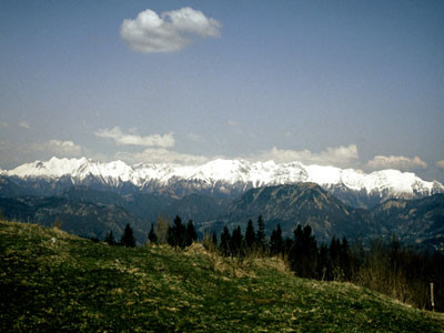
Nous sommes à Idrija, ville lotie dans la vallée au milieu d’un paysage montagneux riche en eau et en bois, ressources qui, combinées à la mine, ont contribué au développement de la deuxième mine de mercure au monde de par sa taille, après Almadeno en Espagne. Par un soir de l’an 1490, un habitant d’un village situé aux alentours plongea son écuelle toute neuve dans l’eau afin d’assouplir le bois. Le matin suivant, il lui fut impossible de la sortir de l’eau car elle était remplie d’un liquide scintillant trop lourd – le mercure. Cette nouvelle se fit rapidement savoir et, en quelques années, une mine vit le jour. Elle fonctionna dès lors sans interruption jusqu’à la fin du siècle dernier. Quinze étages furent creusés dans les profondeurs; la mine fournit plus de cent mille tonnes de métal liquide. Les touristes ont désormais remplacé les mineurs puisque la galerie d’Antoine, la partie la plus ancienne de la mine, a été aménagée en musée qui fait découvrir aux visiteurs la vie des mineurs. Le développement de la mine fut étroitement lié au développement des technologies. Un certain nombre d’inventions sont exposées en ville ou dans les environs. D’imposants murs ont été construits dans les vallées sauvages des montagnes d’Idrija afin de retenir l’eau pour transporter ensuite le bois coupé jusqu’à Idrija. Sur l’Idrijca, on a bâti des barrages spécifiques destinés à arrêter le bois coupé en grande quantité pour pourvoir aux besoins de la mine. Les eaux de l’Idrijca coulaient le long de canaux jusqu’au Kamšt, une pompe ornée d’une gigantesque roue en bois, la plus grande en Europe, destinée à pomper l’eau des profondeurs de la mine. Le puits de Frančiške, ouvert depuis la fin du 18ème siècle, est également aménagé en musée exposant les outils des mineurs et présentant une maison de mineurs rénovée. Le château situé au centre de la ville abritait autrefois les bureaux de la direction de la mine et un dépôt de mercure. Il est aujourd’hui un riche musée présentant tous les détails de la vie des mineurs ainsi que l’histoire de la ville. L’accent est porté sur une autre particularité de la ville, la dentelle d’Idrija. Ces doux motifs blancs ont été importés par les femmes des mineurs et sont l’extrême contraire du monde souterrain sombre et dangereux autour duquel se tissait le destin de la ville et de ses habitants. Idrija, ville de musées, est entourée de tous côtés de crêtes abruptes et de hauts plateaux. Notre chemin mène vers la partie est de la vallée de l’Idrijca. Il monte un versant abrupt pour atteinde une crête en altitude que l’on rejoint au point panoramique de Gore. La crête qui longe l’Idrijca dépasse rarement les mille mètres d’altitude (sommets de Sivka et Bevkov vrh), s’élargit par endroits pour former de petits plateaux (Ledinska planota). Sur les versants et après les sommets, on rencontre parfois de petits hameaux et des fermes isolées. Nombre d’entre eux, comme Slabetova pod Bevkovim vrhom, se sont éteints au profit de la vallée. D’autres, comme Na ravni, situé sous le sommet du même nom a su garder ses enfants en combinant agriculture écologique et tourisme. Sources : http://www.muzej-idrija-cerkno.si/ (Mestni muzej Idrija) http://www.rzs-idrija.si/ (Idrija) (Igor Maher)
Cartes topographiques utiles
Škofjeloško in Cerkljansko hribovje ~ Geodetski zavod Slovenije (1 : 50 000)
Guides de randonnée utiles
Slovenska planinska pot ~ Planinska zveza Slovenije (ISBN 961-6156-11-x)
Vodnik po planinskih postojankah v Sloveniji ~ Planinska zveza Slovenije (ISBN 961-6156-10-1)
Galerie photos
Ajoutez vos propres images!
Commentaires
Coup de cœur, critique ? Entrez votre propre commentaire sur cette étape. Pour des remarques plus générales, merci d’utiliser la fonction commentaire de la page La parole aux Via Alpinistes.
Rembert Biemond - 31/03/2024
We did this stage as the previous on out of season, on March 25, 2024.
It is a stage which can be done very well out of season. The initial text on this page is adequate. It starts with a steep climb and then thereafter it is easy, but long. On the Komoot app there is some confusion about the way out of Idrija. Follow the donots as commented earlier (red ring with white in the middle). It is a 25 km stage so it will keep you busy for a while. We actually did some 85% of the route and then diverted to "Forest Paradise" (Google or booking) a B & B. Can be recommended highly. It is just 500 m from the route. We got a fantastic local dish and a great breakfast. Why didn't we go to the Mountain Hut Planinska koča na Ermanovc? Winterclosed! and no Winter Room.
M&M - 10/09/2023
Der etwas längere Weg zur Planinska koca na Ermanovcu hat sich für uns auf jeden Fall als gute Wahl erwiesen. Sehr freundlicher Hüttenwirt! Wir waren den ganzen Tag im Regen unterwegs und er hat extra für uns den Kachelofen eingeheizt und wir hatten am nächsten Tag tatsächlich wieder trockene Schuhe.
flautix - 20/08/2023
Danke für die Hinweise zur geänderten Wegführung und der Übernachtungsmöglichkeit in Na Lanisah bei Damjian auf dem Baurnhof. Ich habe beides hier in den Track integriert:
https://www.komoot.de/tour/1270649633?ref=wtd&share_token=aS6zOegdFgHfTCUbzG6D9BWFUgjDPNQpdVHDDpM41dt1dZK48n
Neben dem Hochzeitsstadel gibt es über der Gemeinschaftsküche nun sechs schöne Schlafplätze mit Matratzen und Bettwäsche. Man muss also kein Zelt dabeihaben. Wir hatten länger im Voraus per Mail reserviert und Damjans Frau hat uns eine ganze Auswahl an Lebensmitteln für Abendessen und Frühstück in den Kühlschrank gestellt, so dass wir uns bestens selbst versorgen konnten. Übernachtung kostet so 20.- € pro Person plus Kosten für die verbrauchten Lebensmittel. Wir fanden es supernett dort!
Stephanie - 31/05/2023
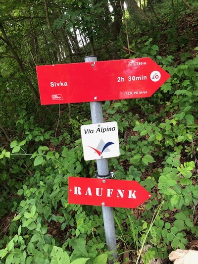
When leaving Idrija, cross the bridge and follow the signs and GPS for route ‘1’ (slovenska planinska pot). Do not follow the GPS for the Via Alpina. When following the ‘1’ you will quickly come across a Via Alpina sign (see photo above). From Ledinsko Razpotje the GPS is correct again.
Ingo - 17/09/2022
We followed the comments of Maria, Ludovic and Karsten (below) and went straight to Damians place. We can 100% confirm what they wrote: Damian is a great guy! We simply showed up without calling or writing before, were allowed to camp at his place and had our first real shower in days. He also sold us some food so we didn´t have to go to Cerkno. It was the last chance to buy food in days. There is no shop in Dolenji Novaki (R8)!!!
Bernd - 01/09/2022
Wir fanden den Doppelweg zur "na Ermanovzu" (Anmeldung am besten auf Englisch via SMS an die angegebenen Nummer) als lohnend: sehr nette Wirte, große Essensportionen zu verhältnismäßig niedrigen Preisen und am nächsten Morgen konnte man erholt die nahen Infos zu den Rapallo-Vereinbarungen aufnehmen.
Bernd - 01/09/2022
Die Wegführung wurde geändert: Es geht nicht mehr zum Marutnik hoch, sondern bald an einer Wegverzweigung mit Infoschild nach links auf einem schönen Waldweg - deutlich weniger anstrengend und in diesem Bereich keine Gefahr, den falschen Weg zu nehmen!
Allerdings an 2 anderen Stellen verstellbare Weidezäune, so dass man ein wenig improvisieren musste (gut auf die Wegmarken achten!)
Julien - 05/08/2022
Decided to resupply at Cerkno as it seems a better option than pod brdo. 2 supermarkets but no camping. Spar has much more choice than mercator. Ended up sleeping in a kindergarten next to the volleyball playground. Nice and quiet with water.
Oliver - 06/07/2022
The climb out of Idrija is quite steep and partly overgrown with stinging nettles. consider long pants. In ledinsko is a small guesthouse that can be used for first or second breakfasts ;)
Karsten - 04/07/2022
I can absolutely confirm the experience of Maria and Ludovic below: The friendly staff of Hostel Idrija had called "Kmetija na Lanisah" and Damian welcomed me at the wedding location some meters after his farm. I was allowed to use the facilities and even sleep in the kitchen due to escape the rain. He even had a beer or me, just bring your own food! When his cows escaped from the paddock later that evening I alarmed hin and chased them back, thus being able to compensate his hospitality a bit ;)
Lovely place (for weddings as well as for tired hikers) and very charming people! Highly recommended to visit them!
Ludovic - 25/06/2022
Following Maria's comment (just below) I phoned the owner of the house who I also found on Google Maps (he has a website). And despite the fact that I wanted to sleep there on a Saturday night when a wedding party was going to take place, he kindly offered to come anyway. Arrived when he was in the middle of a rush for the organization of the wedding, he welcomed me with great kindness and arranged for me to take a shower and show me a pleasant and quiet place to put my tent. The place is beautiful and peaceful and I highly recommend as well as Maria!
Maria - 08/05/2022
This stage ends at the mountain hut Ermanovcu. We thought it is a pity that the last 2,2km (the end of the stage) is the same as the first 2,2 km of stage R8 (the next day). So we asked the owner of the house right at the junction of the stages (2,2 km before the end of stage 7) if it is possible to camp there. He tells us that he wants to start a campsite and shows us the garden where we can stay, the toilets, the hot shower and the cabin with a kitchen. He also has some mattresses in a cabin. It’s also a wedding location and the view is stunning. Highly recommended! Podlanišče 15, 5282 Cerkno 031 403 762 Mojca info@nalanisah.com www.nalanisah.com
Carsten - 10/01/2022
From Idrija to Guest House Kmecki Hram do NOT follow GPS coordinates and official trail description on via-alpina.org (they are WRONG -> no trail). Comments on Maps.Me seem to also direct one to this WRONG route. (AllTrails also uses these wrong GPS data.) Correct: In Idrija, after crossing the bridge and entering the road out of town (as the GPS data indicate), CONTINUE to follow paint marks (red doughnut with white in middle) and hope for the best (you are walking the updated, correct trail but without GPS waymarks). In R7, if one ever finds oneself on an enjoyable, level trail, it’s time to check one’s coordinates. One is almost certainly going in the wrong direction. The guidebook’s altitude gain of 1278m is an underestimate.
Water: pipe out of concrete encasement about half-way through R7 (trickle), and similarly about 85% through (good flow): 46°4’2170N, 14°1’6100E; 46°5’8310N, 14°0’1500E.
Edgard belgian hiker - 09/11/2021
Un grand bravo à l'auberge Robert Fortuna à Idrsek qui a ouvert ce lundi 08/11/2021 et m'a préparé un bon repas le soir alors que j'étais le seul client. Le petit déjeuner était gargantuesque. Je valide à 100%.
Gian franco Basso - 17/06/2019
dormi a Ermanovcu ou je suis passé en2016 la qualité de la prestation a beaucoup régréssé, propreté douteuse ,repas cher et frugal je ne recommande pas
POPEYE GG - 12/06/2018
13 juin 2017
Là encore, partant déjà de Irdrsek (donc en cours de l'étape R7), je suis allé jusqu'à Dolenji Novaki, au début de l'étape R8: en effet, l'hébergement de fin d'étape R7, Planinska Koca na Ermanovcu n'est ouvert qu'en fin de semaine ou alors il faut téléphoner (pas facile comme d'habitude à cause de la langue), et en plus on évite un aller et retour.
Ai passé la nuit à l'hôtel Gacnik aux coordonnées N46°08,733 E14°01,568 (il faut prendre à droite sur la route en sortant du chemin, pas de fléchage!).
Nice people at the restaurant though. Hiking from Idršek to Idrija was kind of a search, there was a sign that leads you into the forest, but the path is blocked with fallen trees and totally overgrown after that. I had fight my way through the forest to get back to the road (which is actually the GPS track).
The youth hostel in Idrija is a nice and cheap place to stay (€11,08 pppn). I was alone in the dorm :-).
Traduction automatique
[Google]
Des gens sympas au restaurant cependant. Randonnée d'Idršek à Idrija était une sorte de recherche, il y avait un panneau qui vous mène dans la forêt, mais le chemin est bloqué par des arbres tombés et totalement envahi par la suite. Je me suis frayé un chemin à travers la forêt pour revenir sur la route (qui est en fait la trace GPS). L'auberge de jeunesse d'Idrija est un lieu de séjour agréable et bon marché (11,08 € pppn). J'étais seul dans le dortoir :-).
Maybe I misunderstood the symbols, but also in Idršek is no grocery store or what so ever.
Traduction automatique
[Google]
J'ai peut-être mal compris les symboles, mais à Idršek, il n'y a pas d'épicerie ou quoi que ce soit.
knfkwnfvw - 31/08/2017
test
Traduction automatique
[Google]
tester
Klaus - 16/09/2016
Ermanovcu dom ist die erste Berhütte auf dieser Tour: kleine Schlafräume mit (warmer) Gemeinschaftsdusche und atemberaubendem Ausblick von der Terrasse.
Leider spricht weder der nette Padrone, noch seine 5 anwesenden Landsleute irgendeine Fremdsprache. Aber für Gulasch mit Polenta, einem Tomatensalat und 3 Bier reicht es. Incl. ÜN/F kostet alles 27€!
Traduction automatique
[Google]
Ermanovcu dom est le premier Berhütte de ce circuit: de petites chambres avec douche commune (chaude) et une vue imprenable depuis la terrasse. Malheureusement, ni le gentil Padrone ni ses 5 compatriotes présents ne parlent une langue étrangère. Mais assez pour goulache avec polenta, une salade de tomates et 3 bières. Incl. La nuit / F coûte 27 €!
Klaus - 16/09/2016
Tour 14.09.2016 - 9h
- 1:45 Aufstieg senkrecht im Wald ohne Serpentinen und mangelhafter Markierung.
- 1h Schotterweg bis zur 3-Sterne Pension Fortuna, die aber erst um 12:00 öffnet.
- 4:15 mit guter Wegeführung aber wiederum schlechter Markierung bis zum Bevkov Vrh.
- 2h auf größtenteils Asphalt-/Schotterstraße stetig bergan bis zur Ermanovcu koča (dom).
Traduction automatique
[Google]
Visite 14.09.2016 - 9h - 1:45 ascension dans la forêt sans serpentines et marquage médiocre. - 1h de route en gravier menant au Pension Fortuna, 3 étoiles, mais ouvert à partir de 12h00. - 4h15 avec un bon acheminement mais encore une fois une mauvaise marque jusqu'à la Bevkov Vrh. - 2h sur une route principalement asphaltée / gravillonnée qui monte régulièrement jusqu'à Ermanovcu koča (dom).
Elisabeth - 30/11/2012
Le début de l'étape est très mal expliqué. Encore un refuge fermé en semaine ! C'est le 3e...Heureusement, je randonne en autonomie complète. A noter qu'il est alors inutile de faire l'AR depuis la ferme Laniscar : la suite de l'itinéraire se prend en dessous de la ferme. L'étape dure au moins 8h.
Check in the Idrija Tourist Office the availability of the Refuge of Ermanovca! They will phone to announce you are coming. The place is not frequented much, and closed on Mondays and Tuesdays.
Traduction automatique
[Google]
Arrivée l'Office de Tourisme Idrija la disponibilité du Refuge de Ermanovca! Ils vont téléphoner pour annoncer que vous venez. L'endroit n'est pas fréquenté beaucoup, et fermé les lundis et mardis.
Alpinisten - 26/09/2011
Achtung!Wenn man auf dem mit einer 1 markierten Weg aufsteigt, dann nicht fälschlicherweise oben nach rechts Richtung Gore dem Wanderzeichen folgen, sondern auf dem Makadamweg Ausschau halten nach einem weiteren Zeichen, das den richtigen Weiterweg geradeaus oder nach links markiert. Wir hatten das übersehen und liefen daher 2 Stunden unbemerkt in die falsche (südliche) Richtung. Der Weg war so schön, daß wir unsren Fehler erst in Urbanovc bemerkten...zum Glück konnte uns dann eine Bäuerin weiterhelfen, indem sie uns ein Stück zurück fuhr, sonst wären wir wieder in Idrija gelandet.
Traduction automatique
[Google]
S'il vous plaît noter: Si vous montez au marquées d'une façon 1, à droite, puis à tort haut vers Gore suivre le sentier balisé, mais gardez à l'affût de macadam un autre signe que la marque le droit chemin à droite ou plus à gauche. Nous avions raté les 2 heures et allaient donc inaperçu dans l'erreur (sud) en direction. La route était si belle que nous avons remarqué une erreur unsren jusqu'à Urbanovc ... heureusement, nous pourrions alors aider un agriculteur en nous donnant un mouvement de recul pièce, sinon nous aurions atterri à Idrija.
Alpinisten - 08/09/2011
Wegen eines Gewitters mußten wir unsere Route leicht abändern und liefen anstelle zur Planinska koca na Ermanovcu nach Cerkno. Im "Hotel Cerkno" kann man wunderbar die regionale Küche genießen und sich im benachbarten Schwimmbad etwas erholen, wenn man sich einen Tag Pause im Hotel gönnen möchte. Man steigt ab hier 4h30 zum Porozen-Gipfel auf. In Cerkno ist die Wegmarkierung etwas versteckt.
Traduction automatique
[Google]
En raison de la tempête, nous avions changer notre route un peu et a couru au lieu de Planinska koca Ermanovcu na à Cerkno. Dans "Hôtel Cerkno" vous pourrez vous détendre et profiter de la cuisine locale et se détendre dans la piscine voisine un peu si vous voulez vous faire plaisir à un jour de repos à l'hôtel. Vous pouvez grimper d'ici au sommet 4:30 Porozen. Cerkno le marqueur chemin est un peu caché.
Apartma Rožica lies in the city centre of town Idrija and offers affordable accomodation with breakfast in rooms with air-conditioning, mini-bar, 24/7 Wifi high-speed Internet access and cooking facilities. The Family informs you about local sights, dishes and possibilities. Warmly recommended to all long-distance hikers going across Via Alpina!
Traduction automatique
[Google]
Apartma Rozica se trouve dans le centre-ville de la ville d'Idrija et propose un hébergement abordable avec petit-déjeuner dans les chambres avec air conditionné, mini-bar, accès 24/7 Internet Wifi haut débit et un équipement de cuisine. La famille vous informe sur les activités locales, des plats et des possibilités. Chaudement recommandé à tous les randonneurs de longue distance traversant la Via Alpina!
robert - 11/07/2011
Mardi 14 juin 2011, le refuge était fermé; il y avait cependant une cabane en construction qui permettait un bivouac confortable et abrité de la pluie .Aller chercher de l'eau auprès des fermes en contrebas du refuge (500m)
gonzom - 10/08/2010
Someone confuse "left"and "right" , "up" and "down" in the description of this stage!
Traduction automatique
[Google]
Quelqu'un confondre «gauche» et «droite», «haut» et «bas» dans la description de cette scène!

 |
7h00 |
25 km
|
1278 m
|
664 m
|
7h00 |
25 km
|
1278 m
|
664 m


Coup de cœur, critique ? Entrez votre propre commentaire sur cette étape. Pour des remarques plus générales, merci d’utiliser la fonction commentaire de la page La parole aux Via Alpinistes.