Hiking (mountain trail, in places narrow and exposed)
Alpine route (equipped or very exposed section, snow field, blocks)
A43
Engedey » Neue Traunsteiner Hütte
|
6h50 |
18.2 km
|
1414 m
|
423 m
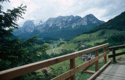
The special feature of this stage is the walk on the “Soleleitungsweg” (the brine pipeline trail). Not only does this trail situated on the sunny side of the Ramsau alpine pastures offer a wonderful panoramic view, but it is also possible to find out everything that is worth knowing about the old brine pipeline. The second part of the hike then leads back into a more alpine landscape, along the boundaries of the national park up to the Neue Traunsteiner hut.
In Engedey, follow the road along the stream northwards to the Söldenköpfl inn, which already offers the first stop-off opportunity. From the inn, follow the well signposted “Soleleitungsweg” (brine trail), which is dotted with illustrated charts, to the Wirtshaus Gerstreit inn. This path is particularly beautiful as it offers a wonderful panorama over the Ramsau plateau on the sunny side and at the same time indicates all that is worth knowing about the brine trail. Follow the signposts and cross the main road to reach the Taubensee lake and the car park at the Schwarzbachwacht pass. From the Schwarzbachwacht pass (referred to as the Wachterl), the trail is marked everywhere with a red point inside a white circle and the trail number 470. It is easy to use, with ladder-like wooden steps built over only a few of the rock steps. It is important not to leave the track, as the tableland in this section is very broken. First of all, a roadway runs westwards on an almost level course. The track begins after approx. 15min (also marking the start of the national park), and climbs to the North West through the wood. You will reach the tableland at an altitude of approx. 1,400m. The trail soon passes the overgrown meadows of the upper Schwegelalm meadow. It runs on an undulating course but without any great variations in altitude, despite several changes in the direction, mainly in a south-westerly direction. Later, it reaches the Saugasse couloir and soon after the Neue Traunsteiner Hut. Just in front of the refuge, a track branches off to the Edelweißlahner, a worthwhile summit situated above the Ramsau. At the Taubensee lake, follow the signs to the Soleleitungsweg, which leads along the sunny slope above the Raumsau to the Engedey. (Christian Scheiter, DAV-Section Traunstein)
Natural and cultural heritage
The picture is one of the most famous motifs of the Berchtesgadener Land district: the parish church of Saints Fabian and Sebastian of Ramsau, the Ramsauer Ache river in front and, in the background, the Mühstürzhörner peaks. Even though the village does lie in the shadow of the Berchtesgaden market, it need not shrink from any comparison in terms of landscape beauty. The village, situated on the banks of the romantic Hintersee lake, attracted a colony of artists in the 19th century who found a home in the cosy parlour of the very traditional inn owned by Babette Auzinger. The painter Carl Rottmann must be thanked for this artistic discovery of the Ramsau. His famous picture entitled "Der Hohe Göll im Alpenglühen" (1846) was purchased by the art-loving Bavarian King Ludwig I., and now hangs in the Bayrische Staatsgemäldesammlung (Bavarian state painting collection). Almost even lovelier than the parish church is the late baroque pilgrimage church, Maria Kunterweg, situated above Ramsau. It was built (around 1731) by the Master Mason Sebastian Stumpfegger from Salzburg in the course of the Counter-Reformation, which culminated in 1732/33 with the expulsion of the Protestants. The ceiling painting shows the victory of the Catholic Church over the "delusional beliefs" – a dark chapter in the history of the prince-provostry of Berchtesgaden. The church is named after a mountain trail over which mainly small animals ("Kunter") are driven to pasture. A Madonna erected in 1689 is said to ward off horrible ghostly faces that made the trail unsafe. This then developed into a pilgrimage and the start of tourism in the Ramsau region. Nestled between the rocky bastions of Hochkalter in the South and the Reiter Alm in the North, the Ramsau region with the Hirschbichl mountain was an important crossing from the prince-provostry of Berchtesgaden to Saalfelden. Another connection from the Stiftsland area to the outer world led past the Raumsau over the Schwarzbachwacht pass – locally known as the "Wachterl" – onto Bavarian territory. It is the starting point for the "Wachterlsteig" trail to the Reiter Alm meadow. Just after the start of the trail along the Schwarzbachwacht pass, it is worth while taking a short detour over the Schwarzbachalmen meadow to the "Schwarzbachloch" cave, which marks the spot of the powerful water source of the Schwarzbach stream that flows into the Saalach. The karstic tableland of the Reiter Alm meadow with its crevices and dolines really does "swallow" the rainwater and melted snow, releasing it again at the foot of the massif. The Reiter Alm, whose Bavarian part belongs to the Berchtesgaden National Park, is home to Germany’s largest cembran pine population, with up to five-hundred-year-old trees. (Michael Kleider)
Other long-distance trails and alternative routes
From the Traunsteiner Hut to the Weitschartenkopf peak, 1,980m, walking time approx. 1h
Favourites, criticisms ? Make your personal comments on this stage. For more general notes please use the comments section of the page Over to the Via Alpinists.

 |
6h50 |
18.2 km
|
1414 m
|
423 m
|
6h50 |
18.2 km
|
1414 m
|
423 m


Favourites, criticisms ? Make your personal comments on this stage. For more general notes please use the comments section of the page Over to the Via Alpinists.