Hiking (mountain trail, in places narrow and exposed)
Alpine route (equipped or very exposed section, snow field, blocks)
C3b
Weisstannen » Elm
|
7h40 |
21.8 km
|
1287 m
|
1297 m
A gentle incline takes you to Alp Foo, from where the mountain trail leads steeply to the Foo pass. After crossing the pass, head to the right of the Raminerbach stream down to Elm, the stage destination.
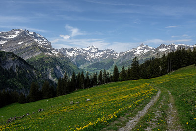
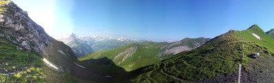
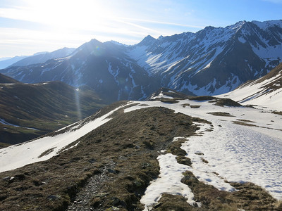
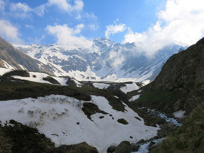
From Weisstannen, walk along the little road further into the valley. Strange high-alpine worlds with ravines and waterfalls make up for the length of the walk before the first climbs begin. Over the boulder fields caused by a rock fall, the trail spirals leftward, each sharp bend taking you further up the slope carpeted in bushes, allowing lovely backward views into the Seez valley and finally opening into the wild Foobach ravine. Behind this, head to the right in the rock wall onto the secured trail to the Foo Alp. Softly shaped green slopes now lead into the Heiteli sheep pastureland. Above this, the sedimentary rock layer of the Foo massif comes clearly into view, a visible sign of the Glarner Hauptüberschiebung (main thrust fault). The terrain now becomes a gentle incline to the Foo pass. The sudden appearance of the Glarner Alps on the other horizon with the last metres has to be one of the most striking moments of the tour. The impressive Vorab, Hausstock and Kärpf mountains dominate the panorama. Next comes a steep descent to the Elmer side, but thanks to the well-built trail it is not a knee-breaker. A little dirt road begins at the Raminer Matt meadow, stretching towards the valley over several wooden bridges. Mighty waterfalls and sparse maple woods enliven this stretch of the route. From Stäfellegg, note should be taken of the short cut of the climbing meadowland path to the Niderenalp cable car station. After passing the sawmill, the trail finally arrives in Elm. (Glarner Wanderwege)
Natural and cultural heritage
Elm The neat little mountain village of Elm lies in the vast basin of the upper Sernftal valley in the midst of lush green meadows and surrounded by beautiful maple and fir trees. It owes its wind-protected setting to the steeply towering summits of the Piz Sardona, Piz Segna, Vorab, Hausstock and Kärpf mountains. A late Gothic church, built in the 15th century, boasts a carved pulpit dating back to 1615 with a memorial plaque for the 114 people who lost their lives in a rock fall on 11 September 1881. The beautiful and well preserved village centre was registered in the inventory of village settings deserving protection with the following buildings: the “Grosshaus”, built in 1585/86, a wooden construction on a walled base that in the late 16th century belonged to the landvogt and bannerherr (city district administrator) Hans Eimer; the “Zentnerhaus”, a simpler building but all the more impressive for its size; the “Suworowhaus”, presumed to have been built in 1671 by landammann (head of cantonal government) J.C. Eimer. It was also the residence of the last Glarus landvogt, J.H. Freitag (1798). In early October 1799, the house served as quarters for General Suworow before he marched his army over the Panixer pass. On 12 and 13 March at 8.55am and on 30 September and 1 October at 8.34am, the sun projects its rays through the Martinsloch gap (gap in the face of the Tschingelhörner) onto the village church. Mineral water sources: in the early 20th century, Elm developed into a climate spa resort with a mineral spring and a spa house. The Elmer Citro mineral water has been bottled there since 1927. (Schweizer Wanderwege)
Useful topographic maps
247 T Sardona ~ Swisstopo (1: 50'000)
Glarnerland-Walensee ~ Hallwag Kümmerly und Frey AG / ISBN 3-259-00865-9 (1: 60'000)
Favourites, criticisms ? Make your personal comments on this stage. For more general notes please use the comments section of the page Over to the Via Alpinists.
Cheryl - 2020-05-27
Ist es möglich auf dem foopass im slafsack evtl. Mit zelt zu übernachten? Oder gibt es eine andere möglichkeit? Schlafen im heu oder so?
2 Tage von Schwendi/Weisstannental nach Elm gewandert. Foopass noch paar wenige, ungefährliche Schneefelder. Alp Vorsiez und Raminer Matt haben geöffnet. Gruss, Andreas
Après cette très belle étape, on trouve un lieu de camping municipal gratuit juste à l'entrée du village, du bois à volonté pour le feu de camp ou le barbecue et des sanitaires. Magnifique village en bois de caractère!
Automatic translation
[Google]
After this beautiful stage, there is a free municipal campsite just at the entrance of the village, wood for the campfire or barbecue and toilets. Beautiful village in character wood!
Hallo, ich mache die Via Alpina ab Vaduz. Am Sonntag steht die Strecke Weisstannen-Elm auf dem Programm. Leider regnet es den ganzen Tag. Ist die Strecke bei Regen machbar oder eher nicht? Ich bin wetterfest, gut trainiert, will aber kein Risiko eingehen. Gibt es allenfalls eine Umgehungsstrecke?
Automatic translation
[Google]
Hello, I am doing the Via Alpina from Vaduz. On Sunday the track Weisstannen-Elm is on the program. Unfortunately it rains all day. Is the route feasible in the rain or not? I'm weatherproof, well trained, but I do not want to take any chances. Is there at best a bypass?
Alistair - 2019-05-29
Hello!
I am walking the Via Alpina 1 for the firs time, starting the 2nd of June. I expect to come across some snow, but does anyone know how much there is on some of the passes at the moment/if they are achievable?
Thanks!
Letztes Wochenende von Mels nach Elm gewandert (Etappe C3a & b zusammen). Bis auf wenige Schneefelder am Foopass, die man aber wunderbar laufen kann, keine Besonderheiten. Ab sofort kann an der Raminer Matt (1896 m, unterhalb vom Foopass) essen & trinken.
Automatic translation
[Google]
Last weekend from Mels to Elm hiked (stage C3a & b together). Except for a few snowfields on Foopass, but you can walk wonderfully, no special features. From now on you can eat and drink at the Raminer Matt (1896 m, below the Foopass).
Thomas Leister - 2017-09-17
Etappe von Sargans bis Vorsiez am 10.09.2017 gewandert. In Strömendem Regen, völlig durchnässt aber zufrieden auf Alp Siez (Vorsiez) bei Ueli Forrer angekommen. Die Übernachtung wurde vorab reserviert und schriftlich bestätigt. Ueli Forrer meinte nur kurz: "Wir haben heute geschlossen, Sie müssen sich etwas anderes suchen." Damit mussten wir weiter ziehen. Ueli hat uns noch einen Bustransfer bis Sargans "organisiert". Der Busfahrer war gerade vor Ort. Wir können von einer Buchung dort nur dringend abraten!
Automatic translation
[Google]
Stage from Sargans to Vorsiez on 10.09.2017 hiked. In pouring rain, completely wet but satisfied on Alp Siez (Vorsiez) arrived at Ueli Forrer. The overnight stay was reserved in advance and confirmed in writing. Ueli Forrer said only briefly: "We have closed today, you have to look for something else." We had to move on. Ueli "organized" us another bus transfer to Sargans. The bus driver was on the spot. We can only advise against booking there!
Tof - 2015-01-07
Trieste-Monaco le 21/8/14
Départ d'Untersass entre Vorsiez et le début de l'ascension du col de Foo.
Alp Foo: n'ont pas accepté de ravitailler (fromage)
Foopass: superbe gypaete barbu (juvénile) dans un cadre géologique magnifique.
A Elm possibilité de dormir dans un petit refuge ouvert et gratuit avec electricité. Situé à l'entrée de la ville derrière l'office de tourisme. Merci à la commune! Epicerie dans le village. Pas de pharmacie.
Automatic translation
[Google]
Trieste-Monaco on 08/21/14 Departure of Untersäss between Vorsiez and the beginning of the ascent of Foo Pass. Alp Foo did not agree to supply (cheese) foopass: bearded vulture beautiful (juvenile) in a beautiful geological setting. A Elm opportunity to sleep in a little open and free shelter with electricity. Located at the entrance of the city behind the tourist office. Thank you to the town! Groceries in the village. No pharmacy.
Etappe C3a und C3b am Samstag/Sonntag (24.05./25.05.14) gewandert. Alles Top ausgeschildert, nur noch wenige Schneefelder, die aber ohne weiteres überquert werden können. In 2 Tagen, bis auf Einheimische, niemanden angetroffen. Bilder unter http://teutoni.blogspot.ch!
Gruss
Andreas
Automatic translation
[Google]
C3a and C3b stage on Saturday / Sunday (24.05. / 05.25.14) migrated. All Top signposted, only a few snow fields that can be crossed easily though. In two days, except for locals, no one encountered. Images under http://teutoni.blogspot.ch! Gruss Andreas
Monaco - Trieste
1897m Raminer Matt water alpine cheese available
Foopass to alp Foo down is only one hour, free coffee and hot water nicely offered on table by friendly owner
Alp Foo - Weisstannen 2h30 down
Weisstannen - Sargans down about an extra push of 3h30
XPaix - 2013-08-27
Ne vous arretez pas au refuge resto de l Alp Vorciez si vous ne voulez pas payer votre verre de boisson gazeuse au sucre 5fr20, du jamais vu en Suisse a part ici et en plus non aimable
Don`t stop to Alp Vorciez, there are pick pockets if you take a glass!
Automatic translation
[Google]
Do not stop at the refuge restaurant Alp Vorciez if you do not want to pay your glass of soft drink 5fr20 sugar, never seen in Switzerland from here and most unlovable Don `t stop to Alp Vorciez, there are pick pockets if you take a glass
Der Weg von Weisstannen führt auf einem neu angelegten schönen Wanderweg dem Bache entlang nach Vorsiez (geänderte Routenführung).
Die Alp Siez ist gut ausgestattet: Schaukäserei, gutes Essen, grosses Lager, Dusche. Im Sommer jeden Sonntag ab 8:30 Uhr grosser Älplerbrunch.
Automatic translation
[Google]
The path of silver fir leads to a newly created beautiful trail along the brook to Vorsiez (modified route guidance). The Alp Siez is well equipped cheese factory, good food, great storage, shower. In summer, every Sunday at 8:30 clock large alpine brunch.
norblauf - 2011-07-26
Auf der Alp Foo bekommt man immer was zu trinken, auch wenn die Leut auf der Alm unterwegs sind, es steht für Wanderer immer etwas da zur Slebstbedienung. Danke.
Automatic translation
[Google]
At Alp Foo you always get something to drink, even if the folks on the farm are on the road, there is always something there for hikers to Slebstbedienung. Thank you.

 |
7h40 |
21.8 km
|
1287 m
|
1297 m
|
7h40 |
21.8 km
|
1287 m
|
1297 m


Favourites, criticisms ? Make your personal comments on this stage. For more general notes please use the comments section of the page Over to the Via Alpinists.