Hiking (mountain trail, in places narrow and exposed)
Alpine route (equipped or very exposed section, snow field, blocks)
R158
Saorge » Breil-sur-Roya
|
1h45 |
8.5 km
|
317 m
|
528 m
This stage leaves Saorge along the valley balcony path above the Roya valley to the stage destination, Breil-sur-Roya, a village typical of the Mediterranean hinterland.
On arriving at Rue Perrissol, do not walk down to the post office, as the street is closed off, but take the street that climbs to the right. 50 metres further, leave Rue Victor Hug on the right and take the one on the left to arrive at a square, where you must turn left onto Rue Virgile Barel for a few metres before heading down Rue “caréra de l'Incisa” towards the Saorge gorges, marked in yellow, until reaching the “carera Soutana” street. At the end of the cement-covered stretch of the way, walk downhill on the right-hand path. This path ends up on a road that must be climbed to the left in order to find the path that descends to the national road RN 204 about 10 metres further on the right. Follow the road to the left (south) for around one hundred metres. Leave it before reaching the bridge and descend along the path towards the river, cross the Dandola ford to then head up along the left bank (be careful, slippery rocks in wet weather). The path arrives on a lovely trail that must be taken to the left for several metres, before it quickly becomes a path that continues above the Roya valley and continues into the forest to join the GR® 52 A trail. Take the upper path to the right in the direction of Breil-sur-Roya (marked in red and white). Further, after crossing the little Caïné valley, leave the path that keeps a level course, and the GR® climbs up in hairpin bends. A few metres later, leave the path across which a large black PVC funnel passes and continue on the GR® that climbs up to the left. The trail continues in the forest and arrives at a pass where several old buildings are situated. The trail continues on an even course to reach a fork in the road after 10min. Leave the GR® to follow the yellow markings. Descend towards the Roya valley, still heading westward and ignoring the various paths that lead off on the right and the left. The trail ends up on a track that must be descended. After a well-marked bend, it leaves towards the north. Stay on the left so as not to miss the path, a few hundred metres further, that heads southward and leads to Breil-sur-Roya. (Paul Guglielmi, CDRP 06)
Natural and cultural heritage
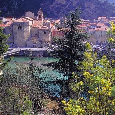
On exiting the market town of Saorge, Via Alpina heads to the gorges by the same name that keep the Roya enclave in a stranglehold for more than 500m. On the other side of the gorges, it is possible to observe the ruins of Malmort Castle and Paspus chapel below Lagouna. The “valley path” on which we scale the mountain, leaves the gorges and rises up a little until, just after a cross, it reaches a high point before plunging back down to the village of Breil and the Roya cove. What is more, the village of Breil-sur-Roya, located at the foot of a rocky peak and on the banks of a cove formed by the stream, nestles at the heart of a fertile olive-grove that used to supply 9 oil mills, one of which was also used to produce flour and today houses a museum. At the heart of this “olive country”, the trees planted on hand-constructed terraces create a very Mediterranean atmosphere. The olive oil, formerly of great repute and dispatched to the Russian court and the Nordic countries, represents half of the harvest while the rest is sold as the famous “olives of Nice”. On arriving in Breil, a little detour to the Cruella Tower, an old Genoese tower built in the XIth century by the counts of Vintimille, lords of the valley, and today a symbol of the market town, proves an interesting viewpoint. In the station of Breil, the Haut-Pays Ecomuseum presents an exhibition on railway transport and techniques that allow visitors to understand the importance of communication points such as La Roya. Furthermore, the old community oven has also been moved to the museum. In the village, the traces of the old ramparts of the famous Genoa Gate through which an old donkey trail passes rise up around the winding, shaded streets in which the houses call to mind the Liguria of the XVIIth and XVIIIth centuries with the trompe-l’oeil stucco on the house facades and the arcaded squares. However, in addition to the aspects of Breil that make it a flagship of Ligurian architecture, it is also possible to discover some religious heritage with penitents’ chapels as big as churches or the baroque-style Sancta Maria in Albis parish church with pink facades designed according to original architecture in the shape of a Greek cross. This listed church, located on the Nisso-Ligurian baroque route, also accommodates a museum of religious art. Once every 4 years in Breuil, a medieval reconstruction, A Stacada, also commemorates the abolition of the “droit de cuissage”. The Benedictine church of St Antoine de Padoua in the South of the town is also of significant interest. Further south, descending the Roya valley towards its Italian part, you will come across the hamlets of Piène and Libre, which are very recent additions to French territory since they were only attached to Breil in 1947, as were the communities of Tende and La Brigue in the Haute-Roya region. (Nicolas Aubertin, Gilles Chappaz, Grande Traversée des Alpes)
Favourites, criticisms ? Make your personal comments on this stage. For more general notes please use the comments section of the page Over to the Via Alpinists.
Kat - 2023-09-08
Most homicidally enraging stage of the entire Red.
All you want is to be in Monaco with a €25 cocktail and here you are yo-yoing uselessly up and down this blackberry-overgrown, poorly-marked, mostly viewless, broiling hot, perpetually deviated trail, listening to the flat motorway by the flat river below, a million times, for a net 200m descent.
I wish that instead of taking this stage I had walked down the road through the tunnel and been hit by a truck.
Look, I am strong. I have walked the previous 157 stages. I was a bit under two hours into this one, including breaks to drink my planned-for-1h45 water ration, cry and curse people's grandmothers, and approximately halfway, when I gave the fuck up.
When the path hits a wooden bridge with water pipes leaving a spring and a DON'T TOUCH sign, you can take an unmarked, unmapped trail to the right, follow the creekbed down to some huts, and emerge on the Chemin de Veil to road-walk to Breil.
Emeline - 2019-01-15
Randonnée faite le 15 janvier 2019, très beau mais la durée est effectivement de 3h30. "En balcon" ne veut pas dire que c'est plat, il y a alternance de descentes et montées plutôt raides. Si on ajoute la montée vers Saorge depuis la gare et la visite de Saorge il faut prévoir la journée.
Automatic translation
[Google]
Hike made January 15, 2019, very beautiful but the duration is actually 3:30. "In balcony" does not mean that it is flat, there is alternation of descents and rather steep climbs. If you add the climb to Saorge from the train station and visit Saorge you have to plan the day.
Berta - 2018-08-31
Für diese Etappe muß man mindestens 3 Stunden planen. Haben im Hotel La Bonne geschlafen. Schönes Zimmer, gute Betten. Leider war es durch das fröhliche Treiben in den benachbarten Bars ziemlich lange etwas laut. Doppelzimmer ohne Frühstück 75 €.
Automatic translation
[Google]
For this stage you have to plan at least 3 hours. Slept in the hotel La Bonne. Nice room, good beds. Unfortunately it was a bit noisy for a long time due to the cheerful activity in the neighboring bars. Double room without breakfast 75 €.
Elisabeth - 2016-11-22
Eh oui ! il y a une contradiction : le descriptif détaillé envoie le randonneur par un agréable itinéraire suivant le GR 52A par la montagne, tandis que le résumé et les points de passage concernent le "sentier valléen" qui suit la bruyante vallée de la Roya. De plus, il ne faut pas 1h45 mais bien 3h - 3h30 : ici tout le monde vous le dira ! Enfin, un éboulement vers la fin de l'étape oblige à une déviation très mal balisée...
Automatic translation
[Google]
Eh yes ! there is a contradiction: the detailed description sends the hiker a pleasant route following the GR 52A by the mountain, while the summary and the points of passage concern the "valled trail" which follows the noisy valley of Roya. In addition, it does not take 1:45 but 3h - 3:30: here everyone will tell you! Finally, a landslide towards the end of the stage requires a deviation very poorly marked ...
You will walk nearby a road and a railway, and it's pretty noisy. Count 3'30" for this stage.
I didn't try it, but I could imagine that the GR52A is more interesting to connect Breil and Saorge, but it will probably be longer.
Maybe it's possible that there are 2 VA's going to Breil-sur-Roya. One following the valley and the other one going up and down?
Hotel "La Bonne Auberge" offers one of the cheapest accommodation in mid-town of Breil-sur-Roya.
Daniel Lepaul - 2010-10-20
Cette étape est donnée pour 1h45 - 8km500 OK avec 1334m de montée et 1532m de descente . Il y a un problème dans le dénivelé ou dans le temps de marche . ça ne parait pas très cohérent .
Automatic translation
[Google]
This step is given for 1:45 - 8km500 OK with 1334m ascent and 1532m of descent. There is a problem in the elevation or the running time. it does not seem very consistent.

 |
1h45 |
8.5 km
|
317 m
|
528 m
|
1h45 |
8.5 km
|
317 m
|
528 m


Favourites, criticisms ? Make your personal comments on this stage. For more general notes please use the comments section of the page Over to the Via Alpinists.