Hiking (mountain trail, in places narrow and exposed)
Alpine route (equipped or very exposed section, snow field, blocks)
R126
Granges de la Vallée Etroite » Névache
|
3h20 |
10.1 km
|
406 m
|
602 m
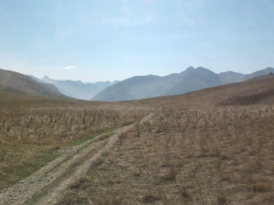
The trail leaves the “Granges de la Vallée Etroite” enclave to head up along the GR® 5-57 trail to the Chavillon lake at the Thures pass. It then heads back down again towards the preserved Clarée valley to reach the traditional village of Névache, the stage destination.
At the Vallée Etroite barns, the GR® 5 trail leaves the carriageway behind to climb up along a winding path towards the south, entering steep forestland. Cut across the Mille hollow, pass the ruins of the Chevillot barn, circument the Chavillon lake on the east side and head across the pastureland to reach the Thures pass (2,194m), an old Franco-Italian border. A slope along the right-hand bank of the Thures stream descends gently to the Thures chalets (2,106m). Continue along the GR® 5 and just after the chalets, leave the trail on the left followed by the GR® 5B variation heading to the Echelle pass to take the right-hand trail, which winds its way rapidly down into the forest. Cross the Roubion stream and walk down into the gorge of this same stream on the right bank along a forest road to reach the Ames chapel (1,623m), located close to the first hamlets of Névache. Leave the GR® 5 trail, which descends to the left, and follow the little road (GR® 57) as far as departmental road D 994g, which must be taken as far as the village of Névache (1,650m). (Marc Buisson, CDRP 05)
Natural and cultural heritage
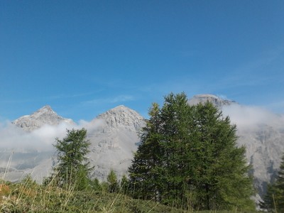
From the Vallée Etroite barns, the trail rises rapidly to above the Paroi des Militaires rock face and arrives at the magnificent Thures plateau, which creates a link between the Vallée Etroite and Clarée valleys. At the Thures pass (2,194m), the Chavillon lake is also located at the edge of the plateau. Via Alpina crosses the plateau to arrive at the alpine chalets, modern-day witnesses to the pastoralism practiced at the foot of the Aiguille Rouge (2,545m). It then plunges down into the Thures coomb, in which you can admire a hoodoo and gypsum quarries, which make this very unstable terrain. A view of the beautiful ravines can also be enjoyed from here. On arriving on the floor of the Clarée valley at Roubion, modern buildings precede the traditional architecture of the village of Névache. The chapis of this village and the galandures of Val-des-Près demonstrate remarkable rural building techniques for the Clarée valley. This valley, whose highest part is a marvellous preserved site, also has a typical grassy carpet covering it between Val-des-Près and Roubion. (Nicolas Aubertin, Gilles Chappaz, Grande Traversée des Alpes)
Favourites, criticisms ? Make your personal comments on this stage. For more general notes please use the comments section of the page Over to the Via Alpinists.
Houdayer Alain - 2022-09-07
Gite d'étape "Le creux des souches" ou l'accueil et la cuisine sont parfaits.
In Névache next tot the parking lot there is a tourist office. They are very helpful to find accommodation. Ask for a dortoir. Do visit the beautiful church with old fresco's.
Elisabeth - 2015-10-14
Temps sous-estimé. Se méfier quand on arrive dans la vallée de Névache au niveau de Roubion : l'épicerie n'est pas à Névache "centre" (église), comme on pourrait s'y attendre, mais bien à Roubion, en face du camping, et à une demi-heure du "centre" !
Automatic translation
[Google]
Time underestimated. Beware when you get in Névache valley at Roubion: the grocery store is not in Névache "center" (church), as one might expect, but in Roubion, opposite the campsite and half an hour of the "center"!
Alpinisten - 2015-08-16
In Névache gibt es seit 2014 ein neues B&B/Gite: Au Vialaou, Tel.: 04.92.54.66.10, adorable Madelène et Michel! Direkt neben der alten Kirche.
Von hier kann man auch gut nach Briancon weiter wandern.
Automatic translation
[Google]
In Névache there since 2014, a new B & B / Gite: Au Vialaou, Tel .: 04.92.54.66.10, adorable Madelene et Michel! Located next to the old church. From here you can continue hiking also good to Briancon.
Tof - 2015-03-21
Trieste-Monaco le 28/9/14
Départ du refuge du Mt Thabor. Descente dans la vallée Etroite. Dans le fond de vallée beaucop d'endroits plats pour bivouaquer. Ce jour au village des Granges, les 2 refuges sont ouverts pour le repas du midi.
Belle montée dans le mélezin puis descente pour rejoindre Névache.
A Névache, petite restauration ouverte ce dimanche après-midi. Pause gouter bienvenue à "l'Aréa" (Hameau de sallé- 05100 NEVACHE).
Pas de ravitaillement ce dimanche à Nevache. Bivouac à la sortie du village sur le chemin de l'étape suivante.
Automatic translation
[Google]
Trieste-Monaco on 28/9/14 out of the shelter of Mt Tabor. Narrow down into the valley. In beaucop valley floor flat places to camp. That day in the village of Granges, the 2 shelters are open for lunch. Beautiful mounted in the Mélezin then descent to join Névache. A Névache, snacks open on Sunday afternoon. Pause welcome to taste the "Statistics Area" (Hamlet Laid NEVACHE 05100). No refueling Sunday in Nevache. Bivouac at the edge of the village on the way to the next step.
Nevache to Chalets des Thures is less than 2hours, locked cabane pastorale on the way up but great location for pitching. Water can be gathered on the way up to Col des Thures. Col des Thures can be windy. Pitched by the locked sheeperd house in June 2013
Granges de la vallee etroite is only 1h10 from the sheeperd house before col des thures
Tippel - 2012-08-05
Gite La Découverte was not our favourite... Dinner was tasteless, toilet on first floor needs renovation, small shower, dog howling in the night and nobody in the house who was responsible for him. Positive was good company of other guests at the big table and self made marmelade for breakfast. Check the other Gites in the village... Névache is very much frequented by French hikers who are staying for a whole week. Early reservation is recommended.
Mountain Girl - 2011-10-27
Don't ask me why, but all of the lodgings in Nevache are pricey and require advance reservations if you land there on a weekend in Sept.!

 |
3h20 |
10.1 km
|
406 m
|
602 m
|
3h20 |
10.1 km
|
406 m
|
602 m


Favourites, criticisms ? Make your personal comments on this stage. For more general notes please use the comments section of the page Over to the Via Alpinists.