Hiking (mountain trail, in places narrow and exposed)
Alpine route (equipped or very exposed section, snow field, blocks)
R105
Godey » Anzeindaz
|
3h00 |
8 km
|
732 m
|
215 m
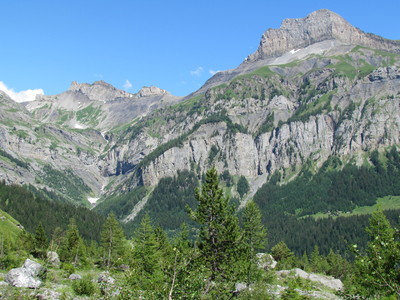
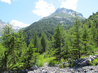
Leave Godey and head to the west through the Derborence primeval forest. In the village of Derborence, a steep climb to the Pas de Cheville pass begins. Continue at the foot of the Diablerets mountain to reach Anzeindaz, the stage destination.
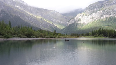
Take the road out of Godet and climb in hairpin bends up to the houses of La Tour. Here, the mountain trail leads on a level course into the debris field caused by rock avalanches dating back to the 18th century, also responsible for the formation of Derborence lake and a mainly untouched forest. Just before Derborence, a gentle downhill course leads to the hamlet. Here, a visit to the nature reserve, one of the last primeval mountain forests in Switzerland, is recommended. Derborence has been immortalised by the novel of the same name by C.F. Ramuz, which tells the story of a local dairy farmer buried in the rockfall of 1749, who was recovered again after several months. A bending trail continues through the wood up the Chevilletal valley. At the Grenier huts, cross the stream and a few hairpin bends take you uphill through a break in the rock to the plateau, from where it is just a short distance to the Cheville pass. Here, the rocky slopes of Les Diablerets are very impressive. The trial leads westward across meadowland directly to Anzeindaz, the stage destination. (Schweizer Wanderwege).
Natural and cultural heritage
Derborence On 23 September 1714, one of the southern rock towers of the Diableret peak tumbled down. Around 50 million cubic metres of scree and boulders thundered into the valley floor of Derborence, burying 14 alpine huts together with their inhabitants and cattle. Rock masses have every so often come loose, the last time in 1944. Scree and boulders from the rock fall of 1714 created an obstruction on the valley floor, blocking the Derbonne stream and creating a lake. Today, a small dam wall ensures that the lake does not dry out completely in summer. As the rock fall also blocked access to the woods on the opposite slope, the area was no longer farmed for around 250 years. Overturned trees lay rotting on the ground and bushes and young trees grew where the old giants had holes torn in their crowns. The oldest trees are around 350 years old and have reached a height of 45 metres and a trunk diameter of 160 centimetres. Thanks to conservationists, this forest has been placed under protection. The vegetation development can now be observed in this forest, scarcely influenced by man, which is rare in Switzerland. A storm in 1990 that wreacked devastating forest damage throughout Switzerland also uprooted trees here. Now it is also possible to observe how natural forests recover from such storm damage. (Schweizer Wanderwege)
Useful topographic maps
272T St-Maurice ~ Swisstopo (1: 50'000)
Grand-St-Bernard / Dents du Midi-Les Diablerets ~ Kümmerly und Frey AG, 3052 Zollikofen (1: 60'000)
Unterwallis / Waeber/Steinbichler ~ Bergverlag Rudolf Rother GmbH (ISBN 3-7633-4128-5)
Du Léman à Sion / André Beerli ~ Editions Ketty & Alexandre (ISBN 2-88114-026-2)
Picture gallery
Add your own pictures!
Comments
Favourites, criticisms ? Make your personal comments on this stage. For more general notes please use the comments section of the page Over to the Via Alpinists.
Steep path down at No Ankle. Many loose rocks to slip on. Easy walk from Derborence to Godey. Godey has a Bed and Breakfast, but it was full. There is an old chapel following the next stage, that is a good alternative.
Tof - 2015-02-06
Trieste-Monaco le 9/9/14
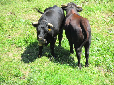
Superbe cadre de Derborence, vaches d'Hérens avant la montée à la Cheville. Paysage de plateaux, vallées cotoyant la haute montagne.
Dans ce pays où Gros Sex, Grand Sex et Sex des Branlettes se côtoient, il n'est pas utile de prononcer le X de Sex, au risque de faire rire tous les locaux!
Les refuges croisés (Anzeindaz, Giacomini, La Vare) sont ouverts mais attention en cette période ils sont a priori sollicités par les classes découvertes des scolaires suisses, quelle chance!
Discussion intéressante avec l'alpagiste du Le Richard, produit du fromage.
Avec les deux compagnons partageant le même chemin, nous poussons jusqu'au pont de Nant.
Bivouac possible avant le hameau dans une cabane ouverte au vent mais protectrice de la pluie. Petit-déjeuner excellentissime à l'auberge du pont de Nant (merci Odile et Guy!).
Automatic translation
[Google]
Trieste-Monaco on 9/9/14 Great part of Derborence, Eringer cows before the climb to the ankle. Landscape of plateaus, valleys cotoyant high mountains. In this country where Big Sex, Sex and Sex of Grand Blowjob coexist, it is not helpful to say the X Sex at the risk of being laughed all local! The Crusaders shelters (Anzeindaz, Giacomini, La Vare) are open at this time but beware they are a priori biased by the discoveries of Swiss school classes, what luck! Interesting discussion with the Alpine dairyman Richard produced cheese. With two companions sharing the same way, we push to Nant bridge. Bivouac possible before the hamlet in an open hut in the wind but protective rain. Excellentissime breakfast at the inn of Nant bridge (Odile and Guy thank you!).
Elisabeth - 2014-12-05
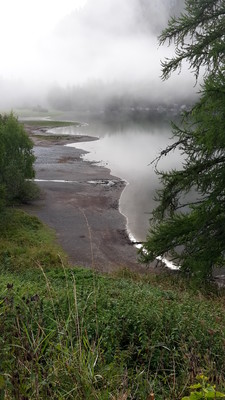
En réalité, le bivouac autorisé n'est pas du tout près du lac de Derborence, où je l'ai cherché, mais en bas dans la vallée !
Automatic translation
[Google]
In reality, the authorized camp is nowhere near the Lake of Derborence, where I searched, but down in the valley!
Joc - 2014-10-28
A Derborence le refuge du Lac est très simple. Dortoir à l'ancienne. Pas de douche, mais lavabo-WC. Repas à la carte (pas de demi-pension). Accueil sympa.
Automatic translation
[Google]
A Derborence the refuge du Lac is very simple. Dormitory old. No shower, but sink-toilet. La carte dining (no half-board). Nice home.
Anzeindaz - Pas de la cheville 30min, smooth way up
Pas de la cheville - Derborence lake 50min down. one possible place to eat in between those 2
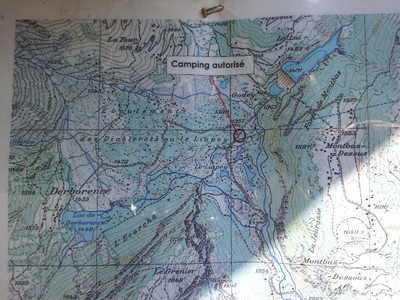
There is an authorized bivouac place in the Derborence lake vincinity (check out my blog for location)
Derborence - Le Godey 45min flat, 2 possible way, trail goes right, otherwise follow boring road (GPX file does)
Jean-Louis GIRAUD - 2013-05-20
Lors de mon passage sur l'alpage d'ANZEINDAZ, seul le Refuge GIACOMINI était ouvert .Accueil trés cordial, tarifs relativement élévés mais avec douches et petits dortoirs ...
Tel : 00 41 (0)24 498 22 95
Email : refuge@anzeindaz.com
Automatic translation
[Google]
During my visit to the alpine Anzeindaz, only GIACOMINI Refuge was open. Home very cordial, relatively high fares but with showers and small dorms ... Tel: 00 41 (0) 24 498 22 95 Email: refuge@anzeindaz.com

 |
3h00 |
8 km
|
732 m
|
215 m
|
3h00 |
8 km
|
732 m
|
215 m


Favourites, criticisms ? Make your personal comments on this stage. For more general notes please use the comments section of the page Over to the Via Alpinists.