Hiking (mountain trail, in places narrow and exposed)
Alpine route (equipped or very exposed section, snow field, blocks)
D56
Roya » Refuge de Longon
|
6h55 |
17.8 km
|
1261 m
|
864 m
The trail leaves the hamlet of Roya via the little Sallevieille valley on the GR® 5, overlooked by Mt Mounier, and then reaches the Crousette pass, followed by the Moulines pass, the entrance to the Mercantour national park. Next, it descends to the Portes de Longon valley and arrives at the hut by the same name, which is the stage destination.
From the hamlet, walk downhill to cross the Roya valley (1,465m). The trail enters Mercantour national park. Then follow the right bank of the little Maïris valley. Just after crossing the Roya ledges via an inlet, cross the Sallevielle valley to then follow the left. Walk past a shepherd’s hut (1,955m) in a very barren site and then take a zigzagging path to cross the pastureland in a generally eastward direction, below the Sallevielle ledge, which is crossed on the left. The trail then heads south again, crossing a terrace (spring and rustic shelter for shepherds leaning against the rock ledge west of the trail) to reach the Croussette pass (2,480m). At the pass, take the left-hand path (south-east) that continues the climb on the side of the Mounier (Mount Noir) as far as the Stèle Valette (2,587m). Follow the crest to the north for about 50 metres and then pass over to the eastern slope. Walk past the Démant ridge (2,438m) and then along the mountainside of Mount Démant (north side) and leave the Démant ledge on the left. The trail quickly drops in altitude to arrive at the Refuge pass (2,068m). It then heads eastward, passing along the northern slope of Mount Moulines, heading to the north east and then arriving at the Moulines pass (1,982m). Walk towards the north west and then the north east to cross the Démant stream (1,820m). Follow a carriageway to pass to the left (north) of the Démant rock and cut across the little Combe Maure valley. Leave the track on the left and take a path that is difficult to distinguish. Pass above the hamlet of Vignols and then cross the Gourgette valley (approximately 1,755m), heading up to the Portes de Longon (1,952m). Continue to the east along the right-hand bank of the Longon stream to reach the Roure cowshed or Longon hut at the eastern end of the Longon plateau (1,883m). (Paul Guglielmi, CDRP 06)
Natural and cultural heritage
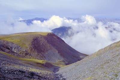
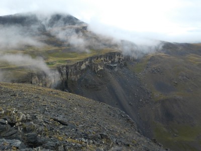
At the entry to the hamlet of Roya, the trail takes the GR® 5 in a high-alpine environment (between 1,800 and 2,500m in altitude) to the centre of the Mercantour National Park. The rocky Roya ridges rise up in the hollow of the little Mairis valley, where there are still some larch trees growing, and mark the beginning of a very mineral landscape. At the foot of Mount Ferrand to the West, the Roya waterfall hurtles down the limestone rocks and illustrates the omnipresence of water as an erosive factor sculpting the countryside. As is the case everywhere else in Mercantour, there are many streams, making this massif a veritable water tower of the southern Alps. The Crousette pass, the highest point of this stage, transports the hiker back to the XIXth century. In fact, several old ruins can be spotted a few metres away in the direction of the Mounier mountain. It was in 1893 that Raphael Bischoffsheim, an astronomy enthusiast, established an annex to the observatory in Nice there. His aim was to measure the speed of light between the two sites using skilful calculations. The building was converted into a hut by the French Alpine Club in 1936 and then abandoned owing to the lack of water and the overly harsh weather conditions. The stela erected lower down in memory of Lieutenant Valette-Viallon, who died in 1936 further down the pass, reminds us of the risks presented by this type of geological formation (rocky ridges and straight shale slopes). The Mounier summit or “Mont Noir” (black mountain), a geomorphological curiosity (hanging syncline) characterised by the blackish colour of its rock and its merciless aridity, offers a unique panoramic viewpoint. Only the Moulines pass, used as summer pastureland for cattle, foretells a return to more gentle terrain. Further downhill, the Vignols valley, a picturesque hamlet in a pastoral setting with a particularly rich religious heritage, was selected in 1993 by the Mercantour National Park as a reintroduction location for the bearded vulture. This large predator with a wingspan of 2m 80 is known for its penchant for bones (which it breaks by dropping them from high altitudes over scree) and the tendons of its carrion. The GR® trail then reaches the Longon Hut on the mountainside, an old cowshed (which explains its long shape) at the entrance to the Mercantour park. This last high-alpine stage marks the transition between the hostile, high-altitude mineral world of this extremity of the Mercantour massif and the lush valleys where farming activity abounds. (Sara Zeidler, Gilles Chappaz, Grande Traversée des Alpes)
Favourites, criticisms ? Make your personal comments on this stage. For more general notes please use the comments section of the page Over to the Via Alpinists.
The refuge de longon was closed (2022) so we went to the lovely village of Roubion and stayed in Le rupicrapra. https://crossingthealpswithease.wordpress.com/2022/08/03/auron-to-roubion/
Socrate Georgiades - 2019-09-06
Très belle étape dans un décor aride et désert. Des bergers un peu partout avec leurs troupeaux de moutons. Au col de Crousette, un panneau trompeur indique le col de Moulines en allant tout droit et sans suivre le chemin qui contourne le mont Mounier. Ce panneau ne mène à rien mais nous a fait perdre près de 3 heures... Nous avons pris une variante en traçant directement vers Vignols et nous avons atterri au très beau vilage de Roubion où nous avons pu bivouaquer dans le jardin des pigeonniers qui surplombe le village. très bon accueil et pizzas au coeur du village.
Automatic translation
[Google]
Very nice stage in an arid and desert scenery. Shepherds everywhere with their herds of sheep. At the Col de Crousette, a deceptive sign indicates the Col de Moulines going straight ahead and without following the path around Mont Mounier. This panel leads to nothing but made us lose nearly 3 hours ... We took a variant by drawing directly to Vignols and we landed in the very beautiful village of Roubion where we were able to bivouac in the garden dovecotes overlooking the village. very welcome and pizza in the heart of the village.
frankie9594 - 2017-10-13
Monaco- Trieste
Beautiful stage. One river was overflowing, ans was difficult to cross between the Refuge and Col des Moulines.
Deep snow by Col de Crousette in early June.
After Col de Crousette, make sure to stay on the correct side of the water. the trail gets confusing at times.
Tof - 2015-07-15
Trieste-Monaco le 14/10/2014
Trajet jusqu'à Roure (approx.30kms) car aucune possibilité d'hébergement sur le parcours en cette période.
Dans le vallon de sallevielle, une bergerie fermée (pt 1955). Un abri est noté sur la carte IGn (pt 2240). Cet abri existe, il sert d'abri de matériel que les bergers ne redescendent pas. Il est donc fermé. S'il est privé il serait bon de le faire rectifier par l'IGN lors de la prochaine mise à jour. C'est trompeur pour le randonneur d'autant qu'il est bien placé en cas de mauvais temps...
Refuge de Longon fermé.
Magnifique et long vallon de Sallevieille. Chamois à volonté sur les deux versants. Depuis le col de Crousette , impression de grands espaces (cuvette et barre du Démant, alpages de Longon). La belle descente sur Roure en chemin forestier avec le brâme du cerf en bruit de fond.
Nuitée à Roure, gîte communal tout équipé et confortable: 15 euros. Bon accueil du personnel municipal. Ravitaillement à St Sauveur le lendemain.
Automatic translation
[Google]
Trieste-Monaco on 10/14/2014 Route to Roure (approx.30kms) since no possibility of accommodation on the course at this time. In sallevielle valley, enclosed sheepfold (pt 1955). A shelter is noted on the map IGn (2240 pt). This shelter exists, it serves as a shelter material that shepherds do not back down. It is therefore closed. If it is private it would be good to have it corrected by IGN at the next update. This is misleading for hikers especially since it is well positioned in the event of bad weather ... Refuge Longon closed. Beautiful and long valley Sallevieille. Chamois at will on both sides. From the pass of Crousette printing large spaces (bowl and bar Demant, pastures of Longon). The beautiful descent on forest road in Roure with Stag belling in the background. Overnight in Roure, communal cottage equipped and comfortable: 15 euros. Good reception of municipal staff. St Sauveur refueling the next day.
Maya CG - 2014-07-23
Freundliche, aber sehr einfache Unterkunft im Refuge de London
Automatic translation
[Google]
Friendly, but very basic accommodation in the Refuge de London
Flat and great walk to portes de Longon in the Mercantour national park, going down to hameau de vignols before going up to Col des Moulines
Col de Crousette was the first spot where neves and lots of snow was still on (mid June 2013 - still more than 50cm of snow). Ask refuge de longon or Roya keeper for condition.
Had to walk few hours in the snow..meet hikers that backed up and canceled there trip due to heavy snow in the col de crousette area
Col de crousette is about 3h30 from refuge de Longon. Took me an extra 3h45 to walk down to Roya with lots of snow
Possible to pitch a tent in the lower part of the Roya hamlet...Gite vieille ecole can provide food (paid 15euros for hot shower and dinner) and accomodation if needed

 |
6h55 |
17.8 km
|
1261 m
|
864 m
|
6h55 |
17.8 km
|
1261 m
|
864 m


Favourites, criticisms ? Make your personal comments on this stage. For more general notes please use the comments section of the page Over to the Via Alpinists.