Create your own guidebook
Download track
Quality : very good
GPX KML CSV
Location
Italy
PIEMONTE
VB
FORMAZZA
Alpi centrali- Lepontine-Punta d' Arbola-Basodino

Key to symbols   
Stage point (start or end of stage)
Intermediate accommodation possibility
Summit
Pass
Town, village
Other locality

Catering
Doctor
Chemist
Bakery / grocery
Hardware / sports shop
Post
Bank / cash dispenser
Train
Coach
Taxi
Open automobile access

A Tarred or paved road
B Dirt track
C Mule trail
D Mountain trail
E Equipped trail (cables, ladders)
F No trail

Stroll / tourism (broad, non-exposed trail)
Hiking (mountain trail, in places narrow and exposed)
Alpine route (equipped or very exposed section, snow field, blocks)
D1 Riale » Alpe Vannino
Trail crossing
  |   3h45   |   11.6 km   |   966 m   |   514 m

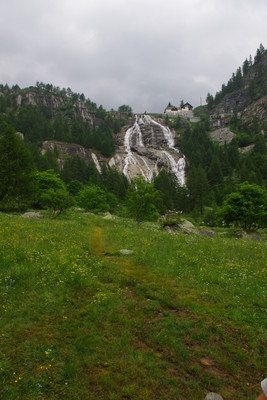
A tarmac road leads from Riale to the Toce waterfalls, from where a steep trail connects with the road to Canza. From here the trail plunges into a wood and heads towards the Lake Vannino dam. The trail passes the Myriam hut on the left and reaches the Vannino-Margaroli hut at the dam itself.

Easier alternative route

There is a dirt track that leads from Canza to the top of the chair lift. The trail begins again from there.

Point Segment
Name Services Information Marking
Riale
1733 m
| A  4.4 km / 1h00
Canza
1421 m
| B  4.7 km / 2h00
Rifugio Myriam
2000 m
| B  2.5 km / 0h45
Alpe Vannino
2185 m
Detailed route description
Natural and cultural heritage
Other long-distance trails and alternative routes
Sentiero Walser, which follows old trails of the 14th century used by the first Walser settlers via the Albrun pass from Binn valley, then Scatta Minoia, Lake Vannino and Canza. Alta Via delle Alpi Ossolane, which crosses the Val Strona, Macugnaga, Antrona, Bognanco, Alpe Veglia e Devero to reach the Val Formazza; since 1995 it is part of the GTA trail.
Useful topographic maps
  • 11 Domodossola e Val Formazza ~ IGC (1:50000)
  • 29 Domodossola ~ Kompass (1:50000)
Useful guidebooks
  • Val Formazza, 36 escursioni scelte- Crosa Lenz P., Frangioni G. ~ (ISBN Domodossola 2002)
  • Ambiente e sistema edilizio negli insediamenti walser di Alagna, Macugnaga e Val Formazza - Mirci Cappa M. ~ quaderni di cultura alpina-Priuli&Verlucca (ISBN Domodossola 2002)
Comments

Favourites, criticisms ? Make your personal comments on this stage. For more general notes please use the comments section of the page Over to the Via Alpinists.


max. 1000 characters
  • FX - 2023-09-19
    Itinéraire réalisé de Riale (D1) à MontCenis (D34) du 19/08 au 12/09/23. L'arrivée sur Riale par train jusqu'à Domodossola (jolie ville à visiter, nombreux commerces et hébergements), puis par bus (voir www.comazzibus.com) : attention, certains bus s'arrêtent à Ponte Formazza (camping) et attention, camping et bivouac interdits dans Vallée du Lac Morasco. Au départ de Riale, 2 options jusqu'à Cascade del Toce, soit par la route, soit en passant derrière l’hôtel. A partir de la cascade (La Frua), plutôt que de descendre à Canza (voir parcours D1), prendre cette variante qui part à droite de la cascade (balisé G35) en direction de la Boccheta del Galo, puis G99 vers Rifugio Margaroli (tout confort) puis permettra un accès en 1h vers Scatta Minoia (bivouac sommaire humide). Très beau parcours de démarrage qui monte direct dans la pente. Les traces gpx : D1 variante : https://www.openrunner.com/route-details/17064668 et D1 (non emprunté) : https://www.openrunner.com/route-details/17064836
  • Peter - 2016-09-22
    In der aktuellen Version vom Internet (22.9.16) sind einige Auslassungen, Irrtümer und Fehler enthalten. Diese habe ich der Organisation mitgeteilt. Bis diese korrigiert sind, kann eine Kopie bei mir (huserpeter@bluewin.ch) angefordert werden.
    Automatic translation [Google]
    The current version of the Internet (22.9.16) contains some omissions, errors and mistakes. I have communicated these to the organization. Until these are corrected, a copy can be requested from me (huserpeter@bluewin.ch).
  • Andreas - 2016-08-01
    Sind im Juli von Ulrichen über den Griespass nach Riale gewandert. Dort im Rifugio Bimse übernachtet. Sehr gastfreundliche und hilfsbereite Betreiber. Nächster Geldautomat in Ponte (11 km). Ab Riale eine gemütliche Wanderung nach Brendo, dort auf dem Campingplatz Hohsand übernachtet. Einfacher, zweckmässiger Campingplatz. Aber hier bis Ponte (Einkaufsmöglichkeiten) und dann mit dem Sessellift (geöffnet ab: 8.30 Uhr) nach Sagersboden. Dort sind wir nicht über den Scatta Minoia Pass, sonder über dem Passo Busin zum Lago Busin sup.! Dort sehr tolle Biwaknacht. Am Lago Busin inf. gibt es auch eine zweckmässige Biwakhütte für ca. 4-6 Personen.
    Automatic translation [Google]
    In July we hiked from Ulrichen over the Griespass to Riale. Stayed there at the Rifugio Bimse. Very hospitable and helpful operators. Nearest ATM in Ponte (11 km). From Riale a leisurely hike to Brendo, where he stayed overnight at the Hohsand campsite. Simple, functional campsite. But here to Ponte (shopping) and then with the chairlift (open from 8.30 clock) to Sagersboden. There we are not over the Scatta Minoia Pass, but over the Passo Busin to the Lago Busin sup.! There very nice bivouac night. On Lake Busin inf. There is also a suitable bivouac hut for about 4-6 people.
  • Clemens - 2016-07-18
    Rifugio Myriam ist eine gute Wahl.
    Von der Schweiz aus kann man gut via Ulrichen mit dem Postauto Richtung Nufenenpass. Und am Abzweig Griesspass aussteigen. Zum Pass ist es nicht weit. Insgesamt braucht man ca. 5 h reine Gehzeit bis zur Rifugio. Man könnte auch die Etappe der GTA laufen direkt von der Staumauer zur Alpe Vannino.
    Automatic translation [Google]
    Rifugio Myriam is a good choice. From Switzerland you can easily via Ulrichen with the post bus direction Nufenenpass. And get off at the branch Griesspass. It is not far to the pass. Altogether one needs approx. 5 h pure walking time to the Rifugio. You could also walk the stage of the GTA directly from the dam to Alpe Vannino.
  • Mountain Girl - 2012-10-19
    Best to reserve at Alpe Vannino, as this refuge frequently fills up. (Rif Myriam not as busy.)
  • Mountain Girl - 2012-10-19
    In Riale I highly recommend B&B "Schtebli", +39 328 3391368 schtebli@libero.it (2 doors down from the pricey "Walser Stube") Daniele has just two cozy rooms for rent. She's a kind hostess, with an angelic little daughter. 35 euros in 2012. Only drawback is: no dinner, and the Walser Stube is 'haute cuisine'! I would go to Rif Bimse for dinner.
  • Helga Bleml - 2011-07-15
    Das Rifugio Myriam kann ich nur waermstens empfehlen! Lorenzo und Cecilia sind zwei super hilfsbereite und liebe Menschen! Die Huette ist sehr gemuetlich und das Essen sehr lecker!
    www.rifugiomiryam.org
    Die Huette hat mittlerweile ganzjaehrig geoeffnet!
    Automatic translation [Google]
    The Rifugio Myriam I can highly recommend it! Lorenzo and Cecilia are two super helpful and nice people! The cabin is very cozy and the food delicious! www.rifugiomiryam.org The lodge has now open all year round!
  • Helga Bleml - 2011-07-15
    Fuer Riale gibt es eine sehr schoene und neue Uebernachtungsmoeglichkeit:
    Rifugio BIMSE bietet Zimmer mit Bad und leckerer Halbpension. www.rifugio-bimse.it
    Die Huette liegt direkt unter der Staumauer des Lago Morasco - grosses Hinweisschild und ist seit zwei Jahren geoeffnet!
    Automatic translation [Google]
    For Riale there is a very nice and new disembarking: Rifugio pumices has en suite rooms and a delicious half-board. www.rifugio-bimse.it The lodge is located just below the dam of Lake Morasco - big sign and is open for two years!
  • Via Alpina International Secretariat - 2010-10-13
    @tom993: hallo, was meinen Sie mit "anmelden"? Sie könnten die Unterkünfte direkt reservieren (auf Name oder Piktogramm klicken für Kontake), oder eine organisierte Tour in der Sektion "Die Wanderungen" buchen. Ihre Erfahrungen können Sie in den Seiten "Via Alpinisten am Wort" mit anderen teilen. Die GPS-Daten sind im Format WGS84 (UTM 32). Ein PDF-Handbuch können Sie direkt auf der Webseite erstellen (im linken Seitenrand jeder Etappenseite oder auf www.via-alpina.org/roadbook. Mit freundlichen Grüßen, Nathalie Morelle, Via Alpina Internationale Koordinatorin
    Automatic translation [Google]
    @ Tom993: hello, what do you mean "sign up" with? You could book the accommodation directly (click on the name or icon for contacts), or an organized tour in the book section "The Walks". You can share your experience in the pages of "Via mountaineers at the word" other. The GPS data is in WGS84 format (UTM 32). A PDF manual you can go directly to the website (Create in the left margin of each page or on stage www.via-alpina.org/roadbook. Sincerely, Nathalie Morelle, Via Alpina International Coordinator
  • tom993 - 2010-10-12
    Hallo, wie kann ich mich anmelden? Welches Format kann ich für mein Oregon 550 wählen um die Route einzuladen? Wie kann ich Ihre Daten für ein Handbuch nutzen? mfg tsp
    Automatic translation [Google]
    Hi, how can I sign up? What format do I choose for my Oregon 550 invite to the route? How can I use your information for a manual? mfg tsp
Last update : 2013-07-15