Hiking (mountain trail, in places narrow and exposed)
Alpine route (equipped or very exposed section, snow field, blocks)
C6
Urnerboden » Altdorf
|
9h30 |
27.8 km
|
783 m
|
1707 m
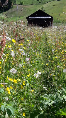
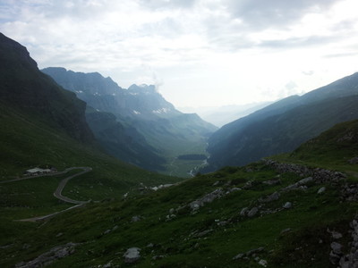
Leave the hamlet of Urner Boden heading westward and follow the old pass trail up to the Klausen pass. From the pass, follow the high-altitude trail past the Heidmanegg to Mettenen. A short, steep climb leads to Spiringen, from where the trail from the Schächental valley leads past Bürglen to Altdorf, the stage destination with its Tell monument.
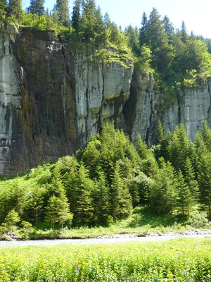
From Urnerboden, there is an approximately 1.5km walk on the very busy road towards the pass before it is possible to leave it in the first hairpin bend. An historical trail leads up to the Klausen pass, crossing the pass road another three times. First a mountain trail and then an alpine pastureland path leads from the pass below the road to Unter Balm, where it crosses the Klausen pass road once again and follows it for around 300m, to turn off onto the alpine trail at the next sharp bend. This trail then leads on an almost level course past the Heidmannegg-Mettenen hamlet. Here, you can enjoy tremendous views into the Schächental and Brunnital valleys and over the summits of the Clariden, Gross Windgällen, Hoch Fulen, Sittliser and Spitzen behind them. In the background, already on the other side of the Reusstal valley, stand the Spannörter, Titlis, Uri-Rotstock, Brisen massifs and many others. To the right, the dolomite-like Schächtentaler Windgällen rock towers look down from their heights. From the “Ob den Hegen” signpost, the mountain trail leads through woodland and across meadows down to Urigen and on to Getschwiler. The pilgrimage chapel, which is worth a visit, dates back to the year 1576 and in addition to many votive images boasts a valuable altarpiece by the famous Flemish painter, Denys Calvaert. From Getschwiler, the farmland path heads down to Spiringen. Follow the Klausen pass road for a short distance before turning off the farmland path at the schoolhouse (large wooden building), to pass the chapel of St. Antoine and arrive on the Klaus pass road. Keep following the Klaus pass road, passing the hamlet of Trudelingen, then turning right off the road and taking the initially gently ascent along the trail to the hamlet of Sigmanig. Above the Schächen river, a footpath leads down along the side of the valley to the bridge to Bürgeln. Between the church and the Tell chapel of Bürglen, walk down on the Hellgasse-Schützengasse street to the Tell memorial in Altdorf. Just after the memorial, take the footpath left down to Altdorf train station. (Schweizer Wanderwege)
Natural and cultural heritage
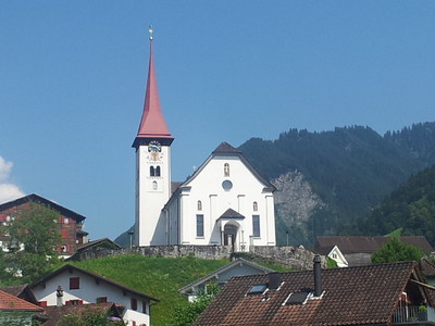
Klausen pass The Klausen pass is mentioned for the first time at the end of the 12th century. Between 1893 and 1899, it was extended into the road. Numerous corrections and improvements have been undertaken since then. Right on the vertex of the pass, on the site of the Klausen chapel known from earlier centuries, stands the lovely Weg chapel built in 1938. Between 1922 and 1934, the road was also the scene of international mountain car races. Bürglen Mentioned as a parish for the first time in the year 857. Two medieval towers, the Meierturm and Wattigerturm, add significant character to the village: in the 13th century, the ivy-entwined Meierturm tower was probably the residence of the Meier (administrators) of the Zurich Fraumünster Abbey, to whom the village and vast estates in Uri belonged until 1426; today, the Wattigerturm tower accommodates the Tell museum. The baroque church of St. Peter and Paul was built according to the plans of the later parish priest Johann Jakob Scolar between 1682 and 1685. The Roman tower is from a previous building dating back to the 13th century. Today, a Tell chapel founded in 1582 and renovated in 1758 with frescoes on the history of Tell stands on the site of the assumed residence of Wilhelm Tell. Opposite the Wattigerturm tower stands the imposing Spielmatt house, which was built in 1609 for landammann (head of cantonal government) Peter Gisler, who had become rich in the French and Venetian services. Somewhat behind the upper exit from the village stands the Loreto chapel with wall paintings, built in 1661. Altdorf The main town of the canton of Uri and the economic and political centre of the region. Today’s town is characterised by buildings dating back to just after the fire caused by the foehn wind in 1799. Out of 269 residential buildings, only 14 remained at the time. The town hall, built in 1805/06 in classical style, contains among other things a vast collection of old Uri provincial banners. Next to this stands the medieval tower with a cupola crown dating back to 1808. In front stands the Tell memorial erected by R. Kissling in 1895, which reminds us of the legendary freedom hero. For the parish church of St. Martin built between 1800 and 1810 on the site of the old church erected between 1602 and 1607, part of the walls of the preceding building were used. The Capucine monastery, founded in 1581 as the first one to the north of the Alps, owes its existence to the influence of Cardinal Karl Borromäus. The church, consecrated in 1585, was reconstructed between 1804 and 1807. The Capucine monastery of St. Karl situated in the south of the village and established in 1677 was one of the few buildings to survive the fire fanned by the foehn in 1799. The doors of the hospice, renovated in 1551 and rebuilt in 1803, were open in particular for impoverished travellers. One of the oldest buildings in the old part of the village is the Suworow house, which also survived the foehn fires of 1693 and 1799. It derives its name from the fact that Russian General Suworow set up his quarters here in 1799, after his troops had gained a passage through the Schöllenenschlucht ravine in spite of bitter resistance from the French.
(Schweizer Wanderwege)
Other long-distance trails and alternative routes
Trans Swiss Trail 1: long distance hiking trail from Porrentruy to Chiasso.
Useful topographic maps
246 T Klausenpass ~ Swisstopo (1: 50'000)
Uri ~ Hallwag Kümmerly + Frey, ISBN 3-259-00873-X ( 1:60'000)
Urner Wanderwegverein ~ URI, Schächental, ISBN 3-906130-14-2
Useful guidebooks
Wanderbuch Uri ~ Gisler Druck AG (ISBN 3-906130-17-7)
Favourites, criticisms ? Make your personal comments on this stage. For more general notes please use the comments section of the page Over to the Via Alpinists.
La journée avait très bien commencé en partant de Asch (la veille, nous avions par hasard quitté la via alpina en suivant un autre GR, magnifique chemin à flanc de falaise qui nous a menés vers ce petit hameau). Ensuite nous avons déchanté en étant obligés de suivre la route vraiment bruyante en raison du nombre effrayant de motos. Tous les restaurants étaient fermés à Spiringen en plein mois de juillet et nous avons eu hâte de prendre le bus pour échapper à cet enfer. Heureusement, Altdorf et son lac sont magnifiques.
Automatic translation
[Google]
The day had started very well from Asch (the day before, we had left the via alpina by another GR, beautiful path on the cliff that led us to this small hamlet). Then we were disillusioned by having to follow the really noisy road due to the scary number of motorcycles. All the restaurants were closed in Spiringen in the middle of July and we were eager to catch the bus to escape this hell. Fortunately, Altdorf and its lake are beautiful.
This stage is follows the road for the most part. if looking for a place to camp in Urnerboden, there is a dirt road by Gasthaus Sonne that goes to the river. There, you can find a place to bivouac.
tof - 2015-01-18
Trieste-Monaco le 24/08/14
A Urnerboden, une épicerie ouverte (le dimanche matin). Peut-être à cause d'une course en montagne ce jour là ?
Passage du Klausenpass pénible à cause des nombreux motards et automobilistes qui prennent la route pour un circuit automobile.
Superbe descente dans un cirque pour atteindre Asch. Joli village traditionnel avec un fuerstelle. Là un bande de joyeux Zurichois francophones m'invitent à partager leur repas. Quel accueil !
Reprise du chemin bien rassasié mais proche de nuit. Bivouac dans une forêt de hêtre juste avant de descendre sur Spiringen.
Automatic translation
[Google]
Trieste-Monaco on 24/8/14 A Urnerboden, open grocery store (Sunday morning). Perhaps because of a mountain race that day? Passage of the Klausen difficult because of the many motorcyclists and motorists hit the road for a motor circuit. Superb descent into a circus to reach Asch. Nice village with a fuerstelle. There a band of merry speaking Zurich invite me to share their meal. What a welcome! Resumption of satiated path but close to night. Bivouac in a beech forest, just before going down to Spiringen.
Monaco - Trieste
The trail from Altdorf up to Spiringen is not interesting (following road)
In Spiringen it can stay low and reach Unterschachen following water stream to Asch then up steep to Klausenpass. Via Alpina trail goes up on a balcony from Spiringen/Urigen. Indoor accomodation can be found in unterschachen.
There is a road at Klausenpass.opened toilet,roof and water available there
joan - 2011-09-22
Good hotel at Klausenpass with dortoirs for trekkers, the Klassenpasshoehe, and good prices too: 60 Sf. for half board in the summer of 2011.
Lou Papé - 2010-07-27
Une variante fortement recommandée entre Bürglen et le Klausenpass: passer par Unterschächen et Äsch. Paysages magnifiques
Automatic translation
[Google]
A variation between Bürglen highly recommended and Klausen: through Unterschächen and Asch. Magnificent landscapes
wfstb - 2010-04-04
Benutzer Holle hat recht. Die zwei nach unten gerichteten Zacken im Höhenprofil (Bereich Klausenpass) sind - ebenso wie die Höhenmeterangaben - völlig unrealistisch.
Automatic translation
[Google]
Users Holle's right. The two downward spikes in the elevation profile (range Klausenpass) are - as well as the altitude information - completely unrealistic.
toller Internetauftritt mit unheimlich viel Informationswert. Bei Etappe C6 ist mir aufgefallen, dass es Ausreisser im GPS-Track gibt und auch das Höhenprofil daher gar nicht passt. Wär klasse, wenn ihr das korrigieren könntet.
Gruss aus dem Schwobaländle, Holle
Automatic translation
[Google]
Hello,
great site with an awful lot of valuable information. In Section C6, I noticed that there are outliers in the GPS track and the height profile does not therefore fit. Would great if you could fix that.
Greetings from the Schwobaländle, Holle

 |
9h30 |
27.8 km
|
783 m
|
1707 m
|
9h30 |
27.8 km
|
783 m
|
1707 m


Favourites, criticisms ? Make your personal comments on this stage. For more general notes please use the comments section of the page Over to the Via Alpinists.