Hiking (mountain trail, in places narrow and exposed)
Alpine route (equipped or very exposed section, snow field, blocks)
C5
Linthal » Urnerboden
|
5h50 |
14.4 km
|
970 m
|
250 m
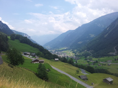
Either climb steeply from Linthal to the car-free Braunwald spa resort or take the rack railway. From here, the pastures trail - all on a level course - leads past Nussbüel to Stafel village. Immediately after crossing the Klausen-Pass road, follow the Flätschbach stream past the hamlet of Argseeli to the hamlet of Urner Boden, the stage destination.
From Linthal train station, head out of the valley alongside the railway tracks. At the railway crossing, turn left to the Stachelberg hotel, a former spa resort. From here, head up through woodland, first turning right and later left of the Trassee lake alongside the Braunwald railway, in sharp bends up to Niederschlacht. For those for whom this steep climb would be too strenuous, the funicular to Braunwald can be used, after which follows a gently descending road to Niederschlacht. Next, remain at the same altitude and follow the alpine trail westward to the Unter Stafel pastureland. After walking through two copses and crossing the Brummbachbrücke bridge before Laui, follow the alpine trail further to reach the Felssporn, from where a fantastic view over Linthal can be enjoyed. Shortly afterwards the trail reaches the alpine farmsteads of Nussbüel. In the wood and above the ledge, the mountain trail leads on a slight incline to the Ober Friteren pastureland. Here, turn onto the alpine trail that leads to the Klausenpass road. The striking Ortstock and the sheer walls of the Jegerstock rise up to the right. Directly behind this, it is possible to see the gap of the Klausen pass. To the left, the snow-covered peaks of the Clariden and the Gemsfairenstock rise up, while the Chamerstock greets you from the opposite side of the valley. After a short walk on the very busy pass road, follow the Flätschbach stream to the left towards Argseeli. Continue alongside the Flätschbach stream to reach the village of Urner Boden. (Schweizer Wanderwege)
Natural and cultural heritage
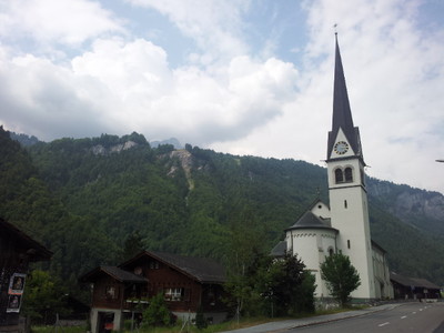
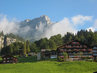
Braunwald Braunwald is situated on a gently climbing panoramic mountain terrace at the foot of the Ortsstock and Eggstöcke mountains. Flowery alpine meadows, beautiful sycamore maples and dark spruce forests surround the widely scattered settlement. Until the 17th century, this very sunny area rich in spring water was only inhabited in summer. With the establishment of a sanatorium (1897) and above all the construction of the funicular (1907), the village developed into a much frequented summer and winter holiday destination of international repute. As there are no road connections with the valley, it is car-free. Urnerboden The Urnerboden area on the other side of the watershed that reaches far into the Glarnerland region is one of the biggest and most beautiful alps in Switzerland. Since the setting of borders in 1196, it belongs to the canton of Uri. Although this is topographically illogical, it can be put down to the Uri people being ahead in terms of population or farming and the resulting established right respected by all. The following legend, however, gives a much more romantic explanation for why this is so: at the time when it was necessary to set the border between Glarus and Uri, the following agreement is said to have been made between the two cantons: at cockcrow, two runners, one from Glarus and the other from Uri, would start out along the path. The border would be set at the point at which they both met. While the people of Uri kept their cockerel on a meagre diet, the people of Glarus fed theirs abundantly. The consequence of this was that Uri’s starving cockerel started crowing at the crack of dawn, while Glarus’s well-nourished cockerel slept soundly until far into the morning. Thus the nimble runner from Uri succeeded in spreading his coat of arms over the entire terrain as far as today’s border. Politically, the popular holiday resort, partially inhabited all year round since 1877, belongs to the community of Spiringen. While 400-500 locals and around 1,200 cattle live here in the summer, only around 70 people stay through the winter, as the road is still unsuitable for travel in winter. The church, consecrated in 1914, contains numerous votive pictures. (Schweizer Wanderwege)
Useful topographic maps
246 T Klausenpass ~ Swisstopo (1: 50'000)
Uri ~ Hallwag Kümmerly + Frey, ISBN 3-259-00873-X ( 1:60'000)
Favourites, criticisms ? Make your personal comments on this stage. For more general notes please use the comments section of the page Over to the Via Alpinists.
Même souci rencontré que dans les Dolomites quand la via alpina suit des routes panoramiques surchargées de motards et de voitures de sport. Sans compter les prix prohibitifs d'un repas au col de Klausen. Mais la récompense du jour, ça a été par hasard de quitter la via alpina vers la gauche, quelques kilomètres après Klausen Pass pour descendre par un vertigineux chemin qui avait servi à la transhumance la veille vers le petit hameau de Asch où il est tout à fait possible de bivouaquer près de la rivière, glacée!
Automatic translation
[Google]
Same concern as in the Dolomites when via alpina follows scenic roads overloaded with bikers and sports cars. Not to mention the prohibitive prices of a meal at Klausen Pass. But the reward of the day, it was by chance to leave the via alpina to the left, a few kilometers after Klausen Pass to descend by a vertiginous road that had been used for transhumance the day before to the small hamlet of Asch where it is all to makes it possible to bivouac near the river, icy!
Tof - 2015-01-09
Trieste-Monaco le 23/8/14
A Linthal, épicerie, toilettes propres à la gare.Montée raide sur Braumwald.
!! Attention lors de l'arrivée à la station de ski et après avoir dépassé la clinique, perte de balisage après le dernier panneau indicateur.
ravitaillement possible en fromage à Nussbuel (pas très bon marché).
Coins de bivouac à Argseeli le long de la rivière dans un petit bosquet. Zones de barbecues présentes. Urnerboden est à 30 minutes à pied.
Automatic translation
[Google]
Trieste-Monaco on 23/8/14 A Linthal, shop, clean toilets stiff gare.Montée on Braumwald. !! Caution when arriving at the ski resort and after passing the clinic, loss markup after the last sign. can Nussbüel refueling cheese (not very cheap). Bivouac corners Argseeli along the river in a small copse. These areas barbecues. Urnerboden is 30 minutes away on foot.
Monaco - Trieste
Possible to bypass Braumwald at Nussbien (by the road), Via Alpina goes up left, there is a trail going down to Linthal on the right (Historisher weg)
Great pizza served at Italian restaurant in linthal if going down bypassing Braumwald
Urnerboden - Linthal (bypassing Braumwald) 2h40 flat + steep way down
Dom Lalot - 2013-09-01
La Gasthof de UrnerBoden est très bien avec des dortoirs ( lager ) pour 35Fr avec petit déjeuner copieux.
Automatic translation
[Google]
Gasthof of Urnerboden is fine with dormitories (lager) for 35GB with breakfast buffet.
Mountain Girl - 2012-04-30
"Backpacker Hotel Adrenaline" is probably the cheapest place to stay in Braunwald, since "Zimmer" for rent are rare in CH. I paid SFR 52 in July 2011 for a comfortable room.
Petite anecdote : nous avions quittés Linthal depuis 2 heures sous des trombes d'eau glaciales, quand à l'arrivée aux alpages de Voder Stafel, les bergers nous , voyant transis de froid, nous offrir, café, vin blanc, schnaps, gâteaux et nous jouèrent un air de cor des alpes. quel bonheur!!. Merci aux gens de ce tout petit canton de Glarus
Automatic translation
[Google]
Anecdote: Linthal since we left two hours under a downpour freezing when on arrival at Voder Stafel pastures, shepherds we saw shivering with cold, we offer coffee, white wine, schnapps, cakes and we played an alphorn air. what happiness!. Thank you to the people of this tiny canton of Glarus

 |
5h50 |
14.4 km
|
970 m
|
250 m
|
5h50 |
14.4 km
|
970 m
|
250 m


Favourites, criticisms ? Make your personal comments on this stage. For more general notes please use the comments section of the page Over to the Via Alpinists.